Altendorf geodata
Altendorf (Bavaria) is a populated place; located in Germany in Europe/Berlin (GMT+2) time zone. With population of 2,017 people, there are 5045 cities with bigger population in this country. Compared to other cities in Germany, 61.6% of cities are located further ↑North; 69.5% of cities are located further ←West and 83.9% of cities have lower elevation than Altendorf. Note1
Administrative division(s):
- Level 1: Bavaria
- Level 2: Upper Franconia
- Level 3: Landkreis Lichtenfels
- Level 4: Weismain


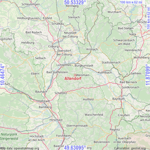
Altendorf GPS coordinates[2]
50° 5' 3.264" North, 11° 10' 4.296" East
| Map corner | latitude | longitude |
|---|---|---|
| Upper-left | 50.53329°, | 10.46474° |
| Center: | 50.08424°, | 11.16786° |
| Lower-right: | 49.63095°, | 11.87099° |
| Map W x H: | 100.3×100.3 km | = 62.3×62.3mi |
| max Lat: | 55.01917° ⇑61.6% North |
| Altendorf: | 50.08424° |
| min Lat: | ⇓38.4% South 47.40724° |
| min Long | Altendorf | max Long |
| 5.92978° | 11.16786° | 14.98853° |
| W 69.5%⇐ | ⇒30.5% E |
Elevation
Elevation of Altendorf is 461 m = 1512 ft, and this is 211.9 m = 695 ft above average elevation for this country.
| Max E: |
1256 m = 4121 ft | 16.1% |
| Altendorf | 461 m 1512 ft | |
| Avg. | 249.1 m = 817 ft | |
Min E: |
-5 m = -16 ft | 83.9% |
See also: Germany elevation on elevation.city.
Geographical zone
Altendorf is located in North temperate zone (between Tropic of Cancer and the Arctic Circle). Distance of this North polar circle is 1832.3 km =1138.5 mi to North.| Distance of | km | miles | from Altendorf |
|---|---|---|---|
| North Pole | 4438.2 | 2757.8 | to North |
| Arctic Circle | 1832.3 | 1138.5 | to North |
| Tropic Cancer | 2962.9 | 1841.1 | to South |
| Equator | 5568.8 | 3460.3 | to South |


Nearby cities:
15 places around Altendorf: (largest is in red/bold)
• Altenkunstadt
7.4 km =4.6 mi,  52°
52°
• Bad Staffelstein
12 km =7.5 mi,  279°
279°
• Burgkunstadt
8.7 km =5.4 mi,  43°
43°
• Hochstadt am Main
7.3 km =4.5 mi,  1°
1°
• Kasendorf
14.2 km =8.8 mi,  111°
111°
• Lichtenfels
10.3 km =6.4 mi,  311°
311°
• Marktgraitz
11.2 km =7 mi,  9°
9°
• Marktzeuln
9.2 km =5.7 mi,  359°
359°
• Michelau
9.6 km =6 mi,  335°
335°
• Redwitz an der Rodach
10.3 km =6.4 mi,  16°
16°
• Schneckenlohe
14.3 km =8.9 mi, 7°
• Stadelhofen
9.3 km =5.8 mi,  166°
166°
• Wattendorf
6.5 km =4 mi,  207°
207°
• Weidhausen bei Coburg
13.4 km =8.3 mi,  351°
351°
• Weismain
5.2 km =3.2 mi,  88°
88°
Sources, notices
• [Note1] Compared only with cities in Germany existing in our database
• [Src1] Map data: © OpenStreetMap contributors (CC-BY-SA)
• [Src2] Other city data from geonames.org with taken over terms of usage.
• [Src3] Geographical zone / Annual Mean Temperature by Robert A. Rohde @ Wikipedia
