Hochfeld geodata
Hochfeld (North Rhine-Westphalia) is a section of populated place; located in Germany in Europe/Berlin (GMT+2) time zone. With population of 16,292 people, there are 974 cities with bigger population in this country. Compared to other cities in Germany, 65.1% of cities are located further ↓South; 96% of cities are located further →East and 84.5% of cities have higher elevation than Hochfeld. Note1
Administrative division(s):
- Level 1: North Rhine-Westphalia
- Level 2: Düsseldorf District
- Level 3: Kreisfreie Stadt Duisburg
- Level 4: Duisburg


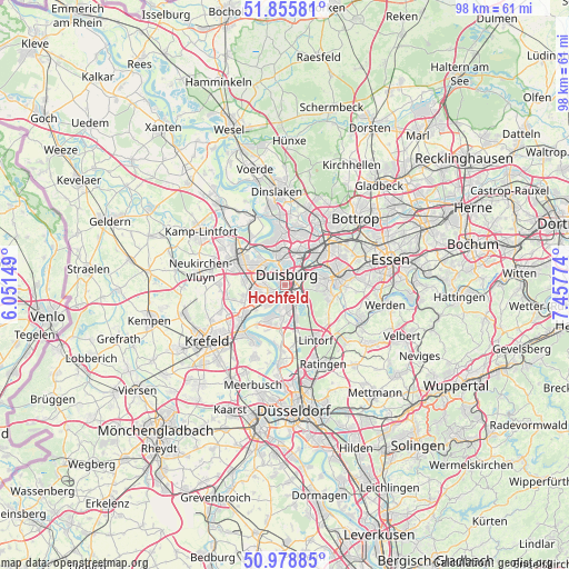
Hochfeld GPS coordinates[2]
51° 25' 9.948" North, 6° 45' 16.632" East
| Map corner | latitude | longitude |
|---|---|---|
| Upper-left | 51.85581°, | 6.05149° |
| Center: | 51.41943°, | 6.75462° |
| Lower-right: | 50.97885°, | 7.45774° |
| Map W x H: | 97.5×97.5 km | = 60.6×60.6mi |
| max Lat: | 55.01917° ⇑34.9% North |
| Hochfeld: | 51.41943° |
| min Lat: | ⇓65.1% South 47.40724° |
| min Long | Hochfeld | max Long |
| 5.92978° | 6.75462° | 14.98853° |
| W 4%⇐ | ⇒96% E |
Elevation
Elevation of Hochfeld is 36 m = 118 ft, and this is 213.1 m = 699 ft below average elevation for this country.
| Max E: |
1256 m = 4121 ft | 84.5% |
| Avg. | 249.1 m = 817 ft | |
| Hochfeld | 36 m = 118 ft | |
Min E: |
-5 m = -16 ft | 15.5% |
See also: Germany elevation on elevation.city.
Geographical zone
Hochfeld is located in North temperate zone (between Tropic of Cancer and the Arctic Circle). Distance of this North polar circle is 1683.9 km =1046.3 mi to North.| Distance of | km | miles | from Hochfeld |
|---|---|---|---|
| North Pole | 4289.8 | 2665.6 | to North |
| Arctic Circle | 1683.9 | 1046.3 | to North |
| Tropic Cancer | 3111.4 | 1933.3 | to South |
| Equator | 5717.3 | 3552.6 | to South |


Nearby cities:
15 places around Hochfeld: (largest is in red/bold)
• Bottrop
16.7 km =10.4 mi,  46°
46°
• Dinslaken
15.9 km =9.9 mi,  357°
357°
• Duisburg
1.6 km =1 mi,  26°
26°
• Düsseldorf-Pempelfort
20.3 km =12.6 mi,  173°
173°
• Essen
18.3 km =11.4 mi,  76°
76°
• Heiligenhaus
18.2 km =11.3 mi,  124°
124°
• Kamp-Lintfort
17.3 km =10.7 mi,  303°
303°
• Krefeld
16.7 km =10.4 mi,  236°
236°
• Meerbusch
19.1 km =11.9 mi,  194°
194°
• Meiderich
5.3 km =3.3 mi,  9°
9°
• Moers
9.3 km =5.8 mi,  294°
294°
• Mülheim
8.8 km =5.5 mi, 80°
• Oberhausen
9.9 km =6.2 mi, 48°
• Ratingen
15.1 km =9.4 mi,  154°
154°
• Rheinberg
17.9 km =11.1 mi,  322°
322°
Sources, notices
• [Note1] Compared only with cities in Germany existing in our database
• [Src1] Map data: © OpenStreetMap contributors (CC-BY-SA)
• [Src2] Other city data from geonames.org with taken over terms of usage.
• [Src3] Geographical zone / Annual Mean Temperature by Robert A. Rohde @ Wikipedia
