Heiligenhaus geodata
Heiligenhaus (North Rhine-Westphalia) is a populated place; located in Germany in Europe/Berlin (GMT+2) time zone. With population of 27,700 people, there are 514 cities with bigger population in this country. Compared to other cities in Germany, 63.6% of cities are located further ↓South; 93.7% of cities are located further →East and 56.2% of cities have higher elevation than Heiligenhaus. Note1
Administrative division(s):
- Level 1: North Rhine-Westphalia
- Level 2: Düsseldorf District
- Level 3: Kreis Mettmann
- Level 4: Heiligenhaus


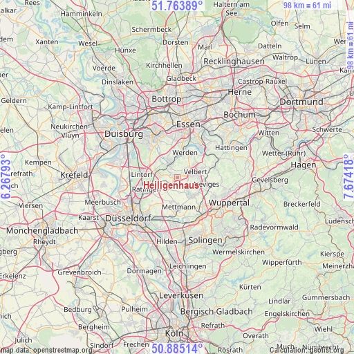
Heiligenhaus GPS coordinates[2]
51° 19' 35.832" North, 6° 58' 15.816" East
| Map corner | latitude | longitude |
|---|---|---|
| Upper-left | 51.76389°, | 6.26793° |
| Center: | 51.32662°, | 6.97106° |
| Lower-right: | 50.88514°, | 7.67418° |
| Map W x H: | 97.7×97.7 km | = 60.7×60.7mi |
| max Lat: | 55.01917° ⇑36.4% North |
| Heiligenhaus: | 51.32662° |
| min Lat: | ⇓63.6% South 47.40724° |
| min Long | Heiligenhaus | max Long |
| 5.92978° | 6.97106° | 14.98853° |
| W 6.3%⇐ | ⇒93.7% E |
Elevation
Elevation of Heiligenhaus is 180 m = 591 ft, and this is 69.1 m = 227 ft below average elevation for this country.
| Max E: |
1256 m = 4121 ft | 56.2% |
| Avg. | 249.1 m = 817 ft | |
| Heiligenhaus | 180 m = 591 ft | |
Min E: |
-5 m = -16 ft | 43.8% |
See also: Germany elevation on elevation.city.
Geographical zone
Heiligenhaus is located in North temperate zone (between Tropic of Cancer and the Arctic Circle). Distance of this North polar circle is 1694.2 km =1052.7 mi to North.| Distance of | km | miles | from Heiligenhaus |
|---|---|---|---|
| North Pole | 4300.1 | 2672 | to North |
| Arctic Circle | 1694.2 | 1052.7 | to North |
| Tropic Cancer | 3101.1 | 1926.9 | to South |
| Equator | 5707 | 3546.2 | to South |


Nearby cities:
15 places around Heiligenhaus: (largest is in red/bold)
• Düsseldorf
17.9 km =11.1 mi,  229°
229°
• Düsseldorf-Pempelfort
16.2 km =10.1 mi, 232°
• Erkrath
12.4 km =7.7 mi,  200°
200°
• Essen
14.7 km =9.1 mi,  11°
11°
• Haan
15.1 km =9.4 mi,  168°
168°
• Hattingen
16.9 km =10.5 mi,  61°
61°
• Hilden
17.8 km =11.1 mi,  189°
189°
• Hochfeld
18.2 km =11.3 mi,  304°
304°
• Mettmann
8.5 km =5.3 mi,  177°
177°
• Mülheim
13.3 km =8.3 mi,  331°
331°
• Oberhausen
18.4 km =11.4 mi,  335°
335°
• Ratingen
9.1 km =5.7 mi,  248°
248°
• Velbert
5.1 km =3.2 mi,  79°
79°
• Wuppertal
14.6 km =9.1 mi,  122°
122°
• Wülfrath
6.8 km =4.2 mi,  136°
136°
Sources, notices
• [Note1] Compared only with cities in Germany existing in our database
• [Src1] Map data: © OpenStreetMap contributors (CC-BY-SA)
• [Src2] Other city data from geonames.org with taken over terms of usage.
• [Src3] Geographical zone / Annual Mean Temperature by Robert A. Rohde @ Wikipedia
