Ratingen geodata
Ratingen (North Rhine-Westphalia) is a populated place; located in Germany in Europe/Berlin (GMT+2) time zone. With population of 91,606 people, there are 107 cities with bigger population in this country. Compared to other cities in Germany, 63.2% of cities are located further ↓South; 95.1% of cities are located further →East and 74.7% of cities have higher elevation than Ratingen. Note1
Administrative division(s):
- Level 1: North Rhine-Westphalia
- Level 2: Düsseldorf District
- Level 3: Kreis Mettmann
- Level 4: Ratingen


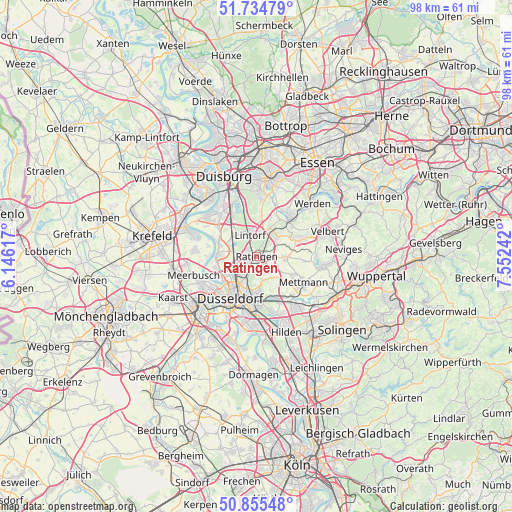
Ratingen GPS coordinates[2]
51° 17' 50.064" North, 6° 50' 57.444" East
| Map corner | latitude | longitude |
|---|---|---|
| Upper-left | 51.73479°, | 6.14617° |
| Center: | 51.29724°, | 6.84929° |
| Lower-right: | 50.85548°, | 7.55242° |
| Map W x H: | 97.8×97.8 km | = 60.8×60.8mi |
| max Lat: | 55.01917° ⇑36.8% North |
| Ratingen: | 51.29724° |
| min Lat: | ⇓63.2% South 47.40724° |
| min Long | Ratingen | max Long |
| 5.92978° | 6.84929° | 14.98853° |
| W 4.9%⇐ | ⇒95.1% E |
Elevation
Elevation of Ratingen is 64 m = 210 ft, and this is 185.1 m = 607 ft below average elevation for this country.
| Max E: |
1256 m = 4121 ft | 74.7% |
| Avg. | 249.1 m = 817 ft | |
| Ratingen | 64 m = 210 ft | |
Min E: |
-5 m = -16 ft | 25.3% |
See also: Ratingen elevation on elevation.city.
Geographical zone
Ratingen is located in North temperate zone (between Tropic of Cancer and the Arctic Circle). Distance of this North polar circle is 1697.5 km =1054.8 mi to North.| Distance of | km | miles | from Ratingen |
|---|---|---|---|
| North Pole | 4303.3 | 2673.9 | to North |
| Arctic Circle | 1697.5 | 1054.8 | to North |
| Tropic Cancer | 3097.8 | 1924.9 | to South |
| Equator | 5703.7 | 3544.1 | to South |


Nearby cities:
15 places around Ratingen: (largest is in red/bold)
• Duisburg
16.1 km =10 mi,  338°
338°
• Düsseldorf
9.8 km =6.1 mi,  211°
211°
• Düsseldorf-Pempelfort
7.9 km =4.9 mi, 213°
• Erkrath
9.3 km =5.8 mi,  153°
153°
• Haan
16.2 km =10.1 mi,  135°
135°
• Heiligenhaus
9.1 km =5.7 mi,  68°
68°
• Hilden
15.4 km =9.6 mi,  158°
158°
• Hochfeld
15.1 km =9.4 mi,  334°
334°
• Kaarst
17.7 km =11 mi,  244°
244°
• Meerbusch
12.3 km =7.6 mi,  246°
246°
• Mettmann
10.2 km =6.3 mi,  120°
120°
• Mülheim
15.2 km =9.4 mi,  8°
8°
• Neuss
15.9 km =9.9 mi,  226°
226°
• Velbert
14.1 km =8.8 mi, 72°
• Wülfrath
13.2 km =8.2 mi,  97°
97°
Sources, notices
• [Note1] Compared only with cities in Germany existing in our database
• [Src1] Map data: © OpenStreetMap contributors (CC-BY-SA)
• [Src2] Other city data from geonames.org with taken over terms of usage.
• [Src3] Geographical zone / Annual Mean Temperature by Robert A. Rohde @ Wikipedia
