Weimar geodata
Weimar (Thuringia) is a seat of a third-order administrative division; located in Germany in Europe/Berlin (GMT+2) time zone. With population of 64,727 people, there are 161 cities with bigger population in this country. Compared to other cities in Germany, 57.8% of cities are located further ↓South; 71.6% of cities are located further ←West and 50.7% of cities have higher elevation than Weimar. Note1


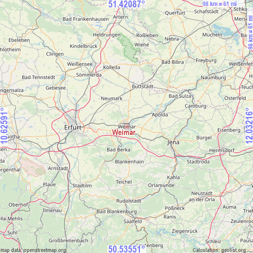
Weimar GPS coordinates[2]
50° 58' 49.08" North, 11° 19' 44.508" East
| Map corner | latitude | longitude |
|---|---|---|
| Upper-left | 51.42087°, | 10.62591° |
| Center: | 50.9803°, | 11.32903° |
| Lower-right: | 50.53551°, | 12.03216° |
| Map W x H: | 98.4×98.4 km | = 61.1×61.1mi |
| max Lat: | 55.01917° ⇑42.2% North |
| Weimar: | 50.9803° |
| min Lat: | ⇓57.8% South 47.40724° |
| min Long | Weimar | max Long |
| 5.92978° | 11.32903° | 14.98853° |
| W 71.6%⇐ | ⇒28.4% E |
Elevation
Elevation of Weimar is 220 m = 722 ft, and this is 29.1 m = 95 ft below average elevation for this country.
| Max E: |
1256 m = 4121 ft | 50.7% |
| Avg. | 249.1 m = 817 ft | |
| Weimar | 220 m = 722 ft | |
Min E: |
-5 m = -16 ft | 49.3% |
See also: Weimar elevation on elevation.city.
Geographical zone
Weimar is located in North temperate zone (between Tropic of Cancer and the Arctic Circle). Distance of this North polar circle is 1732.7 km =1076.6 mi to North.| Distance of | km | miles | from Weimar |
|---|---|---|---|
| North Pole | 4338.6 | 2695.9 | to North |
| Arctic Circle | 1732.7 | 1076.6 | to North |
| Tropic Cancer | 3062.6 | 1903 | to South |
| Equator | 5668.5 | 3522.2 | to South |


Nearby cities:
15 places around Weimar: (largest is in red/bold)
• Buchfart
6.6 km =4.1 mi,  177°
177°
• Ettersburg
6.9 km =4.3 mi,  329°
329°
• Großobringen
5.9 km =3.7 mi,  2°
2°
• Hetschburg
7.8 km =4.8 mi,  195°
195°
• Hopfgarten
7.4 km =4.6 mi,  275°
275°
• Kleinobringen
6 km =3.7 mi,  351°
351°
• Kromsdorf
3.4 km =2.1 mi,  50°
50°
• Mellingen
6.4 km =4 mi,  132°
132°
• Nohra
5.3 km =3.3 mi,  246°
246°
• Oettern
6.7 km =4.2 mi,  162°
162°
• Troistedt
7.6 km =4.7 mi,  226°
226°
• Umpferstedt
6.1 km =3.8 mi,  86°
86°
• Vollersroda
4.9 km =3 mi, 178°
• Wiegendorf
7.3 km =4.5 mi, 87°
• Wohlsborn
6.5 km =4 mi,  24°
24°
Sources, notices
• [Note1] Compared only with cities in Germany existing in our database
• [Src1] Map data: © OpenStreetMap contributors (CC-BY-SA)
• [Src2] Other city data from geonames.org with taken over terms of usage.
• [Src3] Geographical zone / Annual Mean Temperature by Robert A. Rohde @ Wikipedia
