Heroldsbach geodata
Heroldsbach (Bavaria) is a seat of a fourth-order administrative division; located in Germany in Europe/Berlin (GMT+2) time zone. With population of 5,058 people, there are 2805 cities with bigger population in this country. Compared to other cities in Germany, 71.6% of cities are located further ↑North; 66.9% of cities are located further ←West and 58.8% of cities have lower elevation than Heroldsbach. Note1
Administrative division(s):
- Level 1: Bavaria
- Level 2: Upper Franconia
- Level 3: Landkreis Forchheim
- Level 4: Heroldsbach


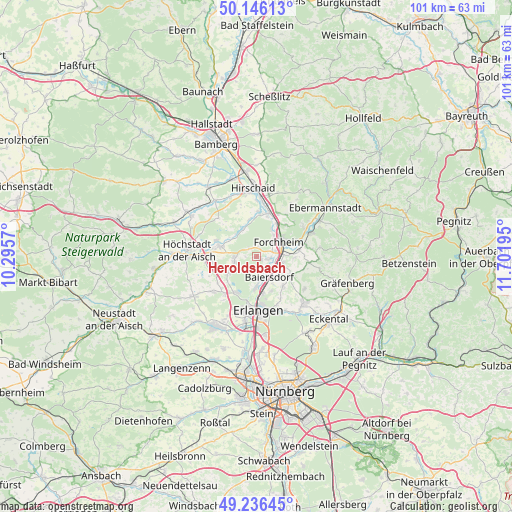
Heroldsbach GPS coordinates[2]
49° 41' 36.312" North, 10° 59' 55.752" East
| Map corner | latitude | longitude |
|---|---|---|
| Upper-left | 50.14613°, | 10.2957° |
| Center: | 49.69342°, | 10.99882° |
| Lower-right: | 49.23645°, | 11.70195° |
| Map W x H: | 101.1×101.1 km | = 62.8×62.8mi |
| max Lat: | 55.01917° ⇑71.6% North |
| Heroldsbach: | 49.69342° |
| min Lat: | ⇓28.4% South 47.40724° |
| min Long | Heroldsbach | max Long |
| 5.92978° | 10.99882° | 14.98853° |
| W 66.9%⇐ | ⇒33.1% E |
Elevation
Elevation of Heroldsbach is 283 m = 928 ft, and this is 33.9 m = 111 ft above average elevation for this country.
| Max E: |
1256 m = 4121 ft | 41.2% |
| Heroldsbach | 283 m 928 ft | |
| Avg. | 249.1 m = 817 ft | |
Min E: |
-5 m = -16 ft | 58.8% |
See also: Germany elevation on elevation.city.
Geographical zone
Heroldsbach is located in North temperate zone (between Tropic of Cancer and the Arctic Circle). Distance of this North polar circle is 1875.8 km =1165.6 mi to North.| Distance of | km | miles | from Heroldsbach |
|---|---|---|---|
| North Pole | 4481.7 | 2784.8 | to North |
| Arctic Circle | 1875.8 | 1165.6 | to North |
| Tropic Cancer | 2919.5 | 1814.1 | to South |
| Equator | 5525.4 | 3433.3 | to South |


Nearby cities:
15 places around Heroldsbach: (largest is in red/bold)
• Adelsdorf
7.8 km =4.8 mi,  285°
285°
• Baiersdorf
4.8 km =3 mi,  145°
145°
• Bubenreuth
7.5 km =4.7 mi,  169°
169°
• Effeltrich
7.8 km =4.8 mi,  119°
119°
• Eggolsheim
9.4 km =5.8 mi,  26°
26°
• Forchheim
5.1 km =3.2 mi,  58°
58°
• Hallerndorf
7.4 km =4.6 mi,  349°
349°
• Hausen
2.4 km =1.5 mi,  100°
100°
• Hemhofen
4.8 km =3 mi,  256°
256°
• Langensendelbach
7.8 km =4.8 mi,  138°
138°
• Marloffstein
9.6 km =6 mi, 151°
• Möhrendorf
6.7 km =4.2 mi,  179°
179°
• Pinzberg
7.4 km =4.6 mi,  93°
93°
• Poxdorf
6.2 km =3.9 mi, 122°
• Röttenbach
6.2 km =3.9 mi,  238°
238°
Sources, notices
• [Note1] Compared only with cities in Germany existing in our database
• [Src1] Map data: © OpenStreetMap contributors (CC-BY-SA)
• [Src2] Other city data from geonames.org with taken over terms of usage.
• [Src3] Geographical zone / Annual Mean Temperature by Robert A. Rohde @ Wikipedia
