Dobersdorf geodata
Dobersdorf (Schleswig-Holstein) is a seat of a fourth-order administrative division; located in Germany in Europe/Berlin (GMT+2) time zone. With population of 1,259 people, there are 6419 cities with bigger population in this country. Compared to other cities in Germany, 96.5% of cities are located further ↓South; 54.9% of cities are located further ←West and 86.3% of cities have higher elevation than Dobersdorf. Note1


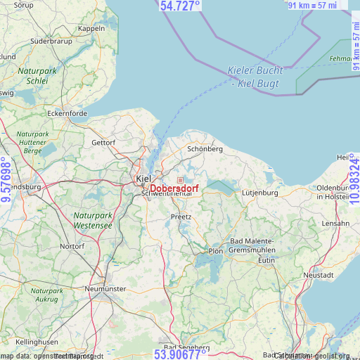
Dobersdorf GPS coordinates[2]
54° 19' 8.148" North, 10° 16' 48.396" East
| Map corner | latitude | longitude |
|---|---|---|
| Upper-left | 54.727°, | 9.57698° |
| Center: | 54.31893°, | 10.28011° |
| Lower-right: | 53.90677°, | 10.98324° |
| Map W x H: | 91.2×91.2 km | = 56.7×56.7mi |
| max Lat: | 55.01917° ⇑3.5% North |
| Dobersdorf: | 54.31893° |
| min Lat: | ⇓96.5% South 47.40724° |
| min Long | Dobersdorf | max Long |
| 5.92978° | 10.28011° | 14.98853° |
| W 54.9%⇐ | ⇒45.1% E |
Elevation
Elevation of Dobersdorf is 32 m = 105 ft, and this is 217.1 m = 712 ft below average elevation for this country.
| Max E: |
1256 m = 4121 ft | 86.3% |
| Avg. | 249.1 m = 817 ft | |
| Dobersdorf | 32 m = 105 ft | |
Min E: |
-5 m = -16 ft | 13.7% |
See also: Germany elevation on elevation.city.
Geographical zone
Dobersdorf is located in North temperate zone (between Tropic of Cancer and the Arctic Circle). Distance of this North polar circle is 1361.5 km =846 mi to North.| Distance of | km | miles | from Dobersdorf |
|---|---|---|---|
| North Pole | 3967.4 | 2465.2 | to North |
| Arctic Circle | 1361.5 | 846 | to North |
| Tropic Cancer | 3433.8 | 2133.7 | to South |
| Equator | 6039.7 | 3752.9 | to South |


Nearby cities:
15 places around Dobersdorf: (largest is in red/bold)
• Brodersdorf
7.4 km =4.6 mi,  344°
344°
• Fahren
4.9 km =3 mi,  44°
44°
• Fiefbergen
8.5 km =5.3 mi,  32°
32°
• Heikendorf
7.4 km =4.6 mi,  315°
315°
• Höhndorf
7.7 km =4.8 mi,  46°
46°
• Klausdorf
4.4 km =2.7 mi,  255°
255°
• Mönkeberg
7.2 km =4.5 mi,  298°
298°
• Passade
5.8 km =3.6 mi,  24°
24°
• Prasdorf
7.3 km =4.5 mi,  10°
10°
• Probsteierhagen
4.8 km =3 mi, 5°
• Raisdorf
4.6 km =2.9 mi,  205°
205°
• Rastorf
5.8 km =3.6 mi,  177°
177°
• Schlesen
3.5 km =2.2 mi,  85°
85°
• Schönkirchen
3.4 km =2.1 mi, 297°
• Stoltenberg
5.7 km =3.5 mi, 52°
Sources, notices
• [Note1] Compared only with cities in Germany existing in our database
• [Src1] Map data: © OpenStreetMap contributors (CC-BY-SA)
• [Src2] Other city data from geonames.org with taken over terms of usage.
• [Src3] Geographical zone / Annual Mean Temperature by Robert A. Rohde @ Wikipedia
