Probsteierhagen geodata
Probsteierhagen (Schleswig-Holstein) is a seat of a fourth-order administrative division; located in Germany in Europe/Berlin (GMT+2) time zone. With population of 1,899 people, there are 5207 cities with bigger population in this country. Compared to other cities in Germany, 97% of cities are located further ↓South; 55.1% of cities are located further ←West and 90.5% of cities have higher elevation than Probsteierhagen. Note1
Administrative division(s):
- Level 1: Schleswig-Holstein
- Level 3: Kreis Plön
- Level 4: Probsteierhagen


Probsteierhagen GPS coordinates[2]
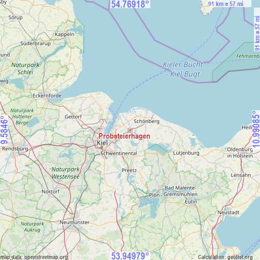
54° 21' 41.508" North, 10° 17' 15.792" East
| Map corner | latitude | longitude |
|---|---|---|
| Upper-left | 54.76918°, | 9.5846° |
| Center: | 54.36153°, | 10.28772° |
| Lower-right: | 53.94979°, | 10.99085° |
| Map W x H: | 91.1×91.1 km | = 56.6×56.6mi |
| max Lat: | 55.01917° ⇑3% North |
| Probsteierhagen: | 54.36153° |
| min Lat: | ⇓97% South 47.40724° |
| min Long | Probsteierhagen | max Long |
| 5.92978° | 10.28772° | 14.98853° |
| W 55.1%⇐ | ⇒44.9% E |
Elevation
Elevation of Probsteierhagen is 20 m = 66 ft, and this is 229.1 m = 752 ft below average elevation for this country.
| Max E: |
1256 m = 4121 ft | 90.5% |
| Avg. | 249.1 m = 817 ft | |
| Probsteierhagen | 20 m = 66 ft | |
Min E: |
-5 m = -16 ft | 9.5% |
See also: Germany elevation on elevation.city.
Geographical zone
Probsteierhagen is located in North temperate zone (between Tropic of Cancer and the Arctic Circle). Distance of this North polar circle is 1356.7 km =843 mi to North.| Distance of | km | miles | from Probsteierhagen |
|---|---|---|---|
| North Pole | 3962.6 | 2462.2 | to North |
| Arctic Circle | 1356.7 | 843 | to North |
| Tropic Cancer | 3438.5 | 2136.6 | to South |
| Equator | 6044.4 | 3755.8 | to South |


Nearby cities:
15 places around Probsteierhagen: (largest is in red/bold)
• Barsbek
4.7 km =2.9 mi,  23°
23°
• Brodersdorf
3.4 km =2.1 mi,  314°
314°
• Dobersdorf
4.8 km =3 mi,  185°
185°
• Fahren
3.2 km =2 mi,  113°
113°
• Fiefbergen
4.7 km =2.9 mi,  58°
58°
• Heikendorf
5.7 km =3.5 mi,  275°
275°
• Höhndorf
5.1 km =3.2 mi,  83°
83°
• Krokau
5.9 km =3.7 mi,  43°
43°
• Lutterbek
4.3 km =2.7 mi,  356°
356°
• Passade
2 km =1.2 mi,  73°
73°
• Prasdorf
2.6 km =1.6 mi, 18°
• Schlesen
5.4 km =3.4 mi,  145°
145°
• Schönkirchen
4.7 km =2.9 mi,  228°
228°
• Stoltenberg
4.2 km =2.6 mi, 107°
• Wendtorf
5.6 km =3.5 mi,  1°
1°
Sources, notices
• [Note1] Compared only with cities in Germany existing in our database
• [Src1] Map data: © OpenStreetMap contributors (CC-BY-SA)
• [Src2] Other city data from geonames.org with taken over terms of usage.
• [Src3] Geographical zone / Annual Mean Temperature by Robert A. Rohde @ Wikipedia
