Heidmühlen geodata
Heidmühlen (Schleswig-Holstein) is a seat of a fourth-order administrative division; located in Germany in Europe/Berlin (GMT+2) time zone. With population of 672 people, there are 8465 cities with bigger population in this country. Compared to other cities in Germany, 92.2% of cities are located further ↓South; 51.4% of cities are located further ←West and 88% of cities have higher elevation than Heidmühlen. Note1


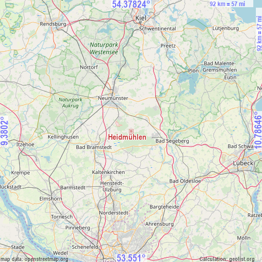
Heidmühlen GPS coordinates[2]
53° 58' 0.012" North, 10° 4' 59.988" East
| Map corner | latitude | longitude |
|---|---|---|
| Upper-left | 54.37824°, | 9.3802° |
| Center: | 53.96667°, | 10.08333° |
| Lower-right: | 53.551°, | 10.78646° |
| Map W x H: | 92×92 km | = 57.2×57.2mi |
| max Lat: | 55.01917° ⇑7.8% North |
| Heidmühlen: | 53.96667° |
| min Lat: | ⇓92.2% South 47.40724° |
| min Long | Heidmühlen | max Long |
| 5.92978° | 10.08333° | 14.98853° |
| W 51.4%⇐ | ⇒48.6% E |
Elevation
Elevation of Heidmühlen is 27 m = 89 ft, and this is 222.1 m = 729 ft below average elevation for this country.
| Max E: |
1256 m = 4121 ft | 88% |
| Avg. | 249.1 m = 817 ft | |
| Heidmühlen | 27 m = 89 ft | |
Min E: |
-5 m = -16 ft | 12% |
See also: Germany elevation on elevation.city.
Geographical zone
Heidmühlen is located in North temperate zone (between Tropic of Cancer and the Arctic Circle). Distance of this North polar circle is 1400.6 km =870.3 mi to North.| Distance of | km | miles | from Heidmühlen |
|---|---|---|---|
| North Pole | 4006.5 | 2489.5 | to North |
| Arctic Circle | 1400.6 | 870.3 | to North |
| Tropic Cancer | 3394.6 | 2109.3 | to South |
| Equator | 6000.5 | 3728.5 | to South |


Nearby cities:
15 places around Heidmühlen: (largest is in red/bold)
• Bark
8.8 km =5.5 mi,  134°
134°
• Bimöhlen
9.5 km =5.9 mi,  246°
246°
• Boostedt
6.4 km =4 mi,  329°
329°
• Fahrenkrug
11.1 km =6.9 mi,  99°
99°
• Groß Kummerfeld
9.3 km =5.8 mi,  0°
0°
• Großenaspe
7.9 km =4.9 mi,  283°
283°
• Hartenholm
7.7 km =4.8 mi,  191°
191°
• Hasenmoor
9.9 km =6.2 mi,  221°
221°
• Latendorf
3.9 km =2.4 mi,  343°
343°
• Negernbötel
11.1 km =6.9 mi,  80°
80°
• Rickling
7.8 km =4.8 mi,  44°
44°
• Struvenhütten
11.3 km =7 mi, 191°
• Todesfelde
9.9 km =6.2 mi,  138°
138°
• Wahlstedt
8.2 km =5.1 mi, 101°
• Wittenborn
10.3 km =6.4 mi,  118°
118°
Sources, notices
• [Note1] Compared only with cities in Germany existing in our database
• [Src1] Map data: © OpenStreetMap contributors (CC-BY-SA)
• [Src2] Other city data from geonames.org with taken over terms of usage.
• [Src3] Geographical zone / Annual Mean Temperature by Robert A. Rohde @ Wikipedia
