Boostedt geodata
Boostedt (Schleswig-Holstein) is a seat of a fourth-order administrative division; located in Germany in Europe/Berlin (GMT+2) time zone. With population of 4,630 people, there are 2975 cities with bigger population in this country. Compared to other cities in Germany, 92.8% of cities are located further ↓South; 50.7% of cities are located further ←West and 81.4% of cities have higher elevation than Boostedt. Note1


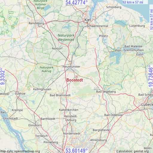
Boostedt GPS coordinates[2]
54° 1' 0.012" North, 10° 1' 59.988" East
| Map corner | latitude | longitude |
|---|---|---|
| Upper-left | 54.42774°, | 9.3302° |
| Center: | 54.01667°, | 10.03333° |
| Lower-right: | 53.60149°, | 10.73646° |
| Map W x H: | 91.9×91.9 km | = 57.1×57.1mi |
| max Lat: | 55.01917° ⇑7.2% North |
| Boostedt: | 54.01667° |
| min Lat: | ⇓92.8% South 47.40724° |
| min Long | Boostedt | max Long |
| 5.92978° | 10.03333° | 14.98853° |
| W 50.7%⇐ | ⇒49.3% E |
Elevation
Elevation of Boostedt is 43 m = 141 ft, and this is 206.1 m = 676 ft below average elevation for this country.
| Max E: |
1256 m = 4121 ft | 81.4% |
| Avg. | 249.1 m = 817 ft | |
| Boostedt | 43 m = 141 ft | |
Min E: |
-5 m = -16 ft | 18.6% |
See also: Germany elevation on elevation.city.
Geographical zone
Boostedt is located in North temperate zone (between Tropic of Cancer and the Arctic Circle). Distance of this North polar circle is 1395.1 km =866.9 mi to North.| Distance of | km | miles | from Boostedt |
|---|---|---|---|
| North Pole | 4001 | 2486.1 | to North |
| Arctic Circle | 1395.1 | 866.9 | to North |
| Tropic Cancer | 3400.2 | 2112.8 | to South |
| Equator | 6006.1 | 3732 | to South |


Nearby cities:
15 places around Boostedt: (largest is in red/bold)
• Arpsdorf
11 km =6.8 mi,  279°
279°
• Bimöhlen
10.8 km =6.7 mi,  210°
210°
• Busdorf
10.2 km =6.3 mi,  18°
18°
• Bönebüttel
7.7 km =4.8 mi, 16°
• Ehndorf
9.5 km =5.9 mi,  293°
293°
• Groß Kummerfeld
4.9 km =3 mi,  41°
41°
• Großenaspe
5.7 km =3.5 mi,  229°
229°
• Heidmühlen
6.4 km =4 mi,  149°
149°
• Latendorf
2.9 km =1.8 mi,  130°
130°
• Neumünster
7.3 km =4.5 mi,  332°
332°
• Padenstedt
8.5 km =5.3 mi,  295°
295°
• Rickling
8.7 km =5.4 mi,  90°
90°
• Tasdorf
9.3 km =5.8 mi,  0°
0°
• Wasbek
10.9 km =6.8 mi,  305°
305°
• Wiemersdorf
10.7 km =6.6 mi, 232°
Sources, notices
• [Note1] Compared only with cities in Germany existing in our database
• [Src1] Map data: © OpenStreetMap contributors (CC-BY-SA)
• [Src2] Other city data from geonames.org with taken over terms of usage.
• [Src3] Geographical zone / Annual Mean Temperature by Robert A. Rohde @ Wikipedia
