Groß Kummerfeld geodata
Groß Kummerfeld (Schleswig-Holstein) is a seat of a fourth-order administrative division; located in Germany in Europe/Berlin (GMT+2) time zone. With population of 1,958 people, there are 5120 cities with bigger population in this country. Compared to other cities in Germany, 93.3% of cities are located further ↓South; 51.4% of cities are located further ←West and 87.7% of cities have higher elevation than Groß Kummerfeld. Note1
Administrative division(s):
- Level 1: Schleswig-Holstein
- Level 3: Kreis Segeberg
- Level 4: Groß Kummerfeld


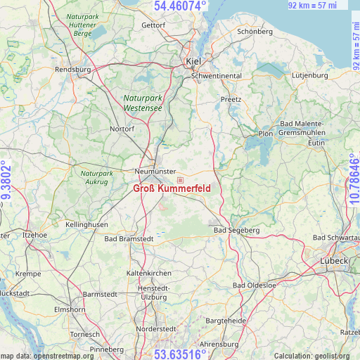
Groß Kummerfeld GPS coordinates[2]
54° 3' 0" North, 10° 4' 59.988" East
| Map corner | latitude | longitude |
|---|---|---|
| Upper-left | 54.46074°, | 9.3802° |
| Center: | 54.05°, | 10.08333° |
| Lower-right: | 53.63516°, | 10.78646° |
| Map W x H: | 91.8×91.8 km | = 57×57mi |
| max Lat: | 55.01917° ⇑6.7% North |
| Groß Kummerfeld: | 54.05° |
| min Lat: | ⇓93.3% South 47.40724° |
| min Long | Groß Kummerfel | max Long |
| 5.92978° | 10.08333° | 14.98853° |
| W 51.4%⇐ | ⇒48.6% E |
Elevation
Elevation of Groß Kummerfeld is 28 m = 92 ft, and this is 221.1 m = 725 ft below average elevation for this country.
| Max E: |
1256 m = 4121 ft | 87.7% |
| Avg. | 249.1 m = 817 ft | |
| Groß Kummerfeld | 28 m = 92 ft | |
Min E: |
-5 m = -16 ft | 12.3% |
See also: Germany elevation on elevation.city.
Geographical zone
Groß Kummerfeld is located in North temperate zone (between Tropic of Cancer and the Arctic Circle). Distance of this North polar circle is 1391.4 km =864.6 mi to North.| Distance of | km | miles | from Groß Kummerfeld |
|---|---|---|---|
| North Pole | 3997.3 | 2483.8 | to North |
| Arctic Circle | 1391.4 | 864.6 | to North |
| Tropic Cancer | 3403.9 | 2115.1 | to South |
| Equator | 6009.8 | 3734.3 | to South |


Nearby cities:
15 places around Groß Kummerfeld: (largest is in red/bold)
• Boostedt
4.9 km =3 mi,  221°
221°
• Bornhöved
10 km =6.2 mi,  79°
79°
• Busdorf
5.9 km =3.7 mi,  359°
359°
• Bönebüttel
3.9 km =2.4 mi,  343°
343°
• Großharrie
7.7 km =4.8 mi, 343°
• Gönnebek
7.4 km =4.6 mi,  90°
90°
• Heidmühlen
9.3 km =5.8 mi,  180°
180°
• Latendorf
5.7 km =3.5 mi,  191°
191°
• Neumünster
7.2 km =4.5 mi,  292°
292°
• Rendswühren
7.5 km =4.7 mi,  60°
60°
• Rickling
6.6 km =4.1 mi,  124°
124°
• Ruhwinkel
10.3 km =6.4 mi, 57°
• Schillsdorf
8.1 km =5 mi,  23°
23°
• Tasdorf
6.4 km =4 mi,  329°
329°
• Trappenkamp
8.7 km =5.4 mi,  97°
97°
Sources, notices
• [Note1] Compared only with cities in Germany existing in our database
• [Src1] Map data: © OpenStreetMap contributors (CC-BY-SA)
• [Src2] Other city data from geonames.org with taken over terms of usage.
• [Src3] Geographical zone / Annual Mean Temperature by Robert A. Rohde @ Wikipedia
