Heide geodata
Heide (Schleswig-Holstein) is a seat of a third-order administrative division; located in Germany in Europe/Berlin (GMT+2) time zone. With population of 20,599 people, there are 748 cities with bigger population in this country. Compared to other cities in Germany, 95.1% of cities are located further ↓South; 64% of cities are located further →East and 92.7% of cities have higher elevation than Heide. Note1


Heide GPS coordinates[2]
54° 11' 44.844" North, 9° 5' 55.68" East
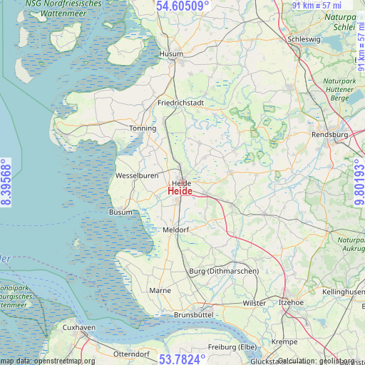
| Map corner | latitude | longitude |
|---|---|---|
| Upper-left | 54.60509°, | 8.39568° |
| Center: | 54.19579°, | 9.0988° |
| Lower-right: | 53.7824°, | 9.80193° |
| Map W x H: | 91.5×91.5 km | = 56.9×56.9mi |
| max Lat: | 55.01917° ⇑4.9% North |
| Heide: | 54.19579° |
| min Lat: | ⇓95.1% South 47.40724° |
| min Long | Heide | max Long |
| 5.92978° | 9.0988° | 14.98853° |
| W 36%⇐ | ⇒64% E |
Elevation
Elevation of Heide is 14 m = 46 ft, and this is 235.1 m = 771 ft below average elevation for this country.
| Max E: |
1256 m = 4121 ft | 92.7% |
| Avg. | 249.1 m = 817 ft | |
| Heide | 14 m = 46 ft | |
Min E: |
-5 m = -16 ft | 7.3% |
See also: Germany elevation on elevation.city.
Geographical zone
Heide is located in North temperate zone (between Tropic of Cancer and the Arctic Circle). Distance of this North polar circle is 1375.2 km =854.5 mi to North.| Distance of | km | miles | from Heide |
|---|---|---|---|
| North Pole | 3981.1 | 2473.7 | to North |
| Arctic Circle | 1375.2 | 854.5 | to North |
| Tropic Cancer | 3420.1 | 2125.2 | to South |
| Equator | 6026 | 3744.4 | to South |


Nearby cities:
15 places around Heide: (largest is in red/bold)
• Barkenholm
6.9 km =4.3 mi,  52°
52°
• Hemmingstedt
5.5 km =3.4 mi,  202°
202°
• Lieth
5.1 km =3.2 mi,  209°
209°
• Linden
8.2 km =5.1 mi,  42°
42°
• Lohe-Rickelshof
2 km =1.2 mi,  244°
244°
• Norderheistedt
6.9 km =4.3 mi,  28°
28°
• Norderwöhrden
5.4 km =3.4 mi,  275°
275°
• Nordhastedt
6.4 km =4 mi,  120°
120°
• Oesterwurth
7.9 km =4.9 mi,  287°
287°
• Ostrohe
2.9 km =1.8 mi, 37°
• Süderheistedt
5.4 km =3.4 mi, 35°
• Weddingstedt
4.3 km =2.7 mi,  353°
353°
• Wesseln
2.1 km =1.3 mi,  317°
317°
• Wiemerstedt
8 km =5 mi,  8°
8°
• Wöhrden
7.2 km =4.5 mi, 243°
Sources, notices
• [Note1] Compared only with cities in Germany existing in our database
• [Src1] Map data: © OpenStreetMap contributors (CC-BY-SA)
• [Src2] Other city data from geonames.org with taken over terms of usage.
• [Src3] Geographical zone / Annual Mean Temperature by Robert A. Rohde @ Wikipedia
