Hausen geodata
Hausen (Rheinland-Pfalz) is a populated place; located in Germany in Europe/Berlin (GMT+2) time zone. With population of 2,009 people, there are 5056 cities with bigger population in this country. Compared to other cities in Germany, 51.9% of cities are located further ↑North; 88.5% of cities are located further →East and 63.6% of cities have higher elevation than Hausen. Note1
Administrative division(s):
- Level 1: Rheinland-Pfalz
- Level 3: Landkreis Neuwied
- Level 4: Hausen (Wied)


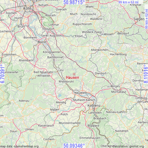
Hausen GPS coordinates[2]
50° 32' 32.712" North, 7° 24' 25.308" East
| Map corner | latitude | longitude |
|---|---|---|
| Upper-left | 50.98715°, | 6.70391° |
| Center: | 50.54242°, | 7.40703° |
| Lower-right: | 50.09346°, | 8.11016° |
| Map W x H: | 99.4×99.4 km | = 61.8×61.8mi |
| max Lat: | 55.01917° ⇑51.9% North |
| Hausen: | 50.54242° |
| min Lat: | ⇓48.1% South 47.40724° |
| min Long | Hausen | max Long |
| 5.92978° | 7.40703° | 14.98853° |
| W 11.5%⇐ | ⇒88.5% E |
Elevation
Elevation of Hausen is 128 m = 420 ft, and this is 121.1 m = 397 ft below average elevation for this country.
| Max E: |
1256 m = 4121 ft | 63.6% |
| Avg. | 249.1 m = 817 ft | |
| Hausen | 128 m = 420 ft | |
Min E: |
-5 m = -16 ft | 36.4% |
See also: Germany elevation on elevation.city.
Geographical zone
Hausen is located in North temperate zone (between Tropic of Cancer and the Arctic Circle). Distance of this North polar circle is 1781.4 km =1106.9 mi to North.| Distance of | km | miles | from Hausen |
|---|---|---|---|
| North Pole | 4387.3 | 2726.1 | to North |
| Arctic Circle | 1781.4 | 1106.9 | to North |
| Tropic Cancer | 3013.9 | 1872.8 | to South |
| Equator | 5619.8 | 3492 | to South |


Nearby cities:
15 places around Hausen: (largest is in red/bold)
• Bad Hönningen
7.3 km =4.5 mi,  247°
247°
• Bonefeld
6.2 km =3.9 mi,  109°
109°
• Breitscheid
5.1 km =3.2 mi,  30°
30°
• Datzeroth
2.9 km =1.8 mi,  166°
166°
• Ehlscheid
5.2 km =3.2 mi,  126°
126°
• Hammerstein
7.7 km =4.8 mi,  211°
211°
• Krunkel
8 km =5 mi,  55°
55°
• Kurtscheid
4.3 km =2.7 mi,  103°
103°
• Leubsdorf
7.6 km =4.7 mi,  276°
276°
• Niederbreitbach
1.7 km =1.1 mi,  143°
143°
• Obersteinebach
7.1 km =4.4 mi,  49°
49°
• Rheinbrohl
7 km =4.3 mi,  227°
227°
• Roßbach
3.7 km =2.3 mi,  10°
10°
• Sankt Katharinen
4.8 km =3 mi,  339°
339°
• Waldbreitbach
1.1 km =0.7 mi,  38°
38°
Sources, notices
• [Note1] Compared only with cities in Germany existing in our database
• [Src1] Map data: © OpenStreetMap contributors (CC-BY-SA)
• [Src2] Other city data from geonames.org with taken over terms of usage.
• [Src3] Geographical zone / Annual Mean Temperature by Robert A. Rohde @ Wikipedia
