Roßbach geodata
Roßbach (Rheinland-Pfalz) is a seat of a fourth-order administrative division; located in Germany in Europe/Berlin (GMT+2) time zone. With population of 937 people, there are 7398 cities with bigger population in this country. Compared to other cities in Germany, 51.2% of cities are located further ↑North; 88.4% of cities are located further →East and 64.7% of cities have higher elevation than Roßbach. Note1


Roßbach GPS coordinates[2]
50° 34' 30" North, 7° 24' 57.996" East
| Map corner | latitude | longitude |
|---|---|---|
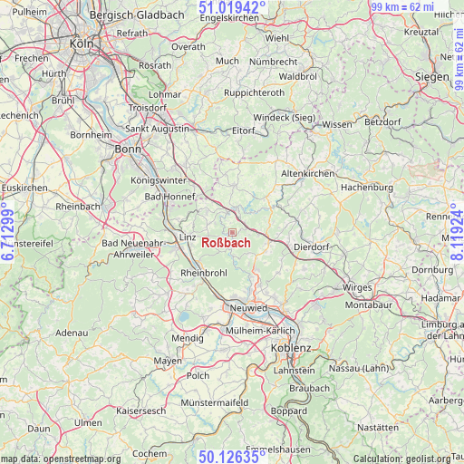
| Upper-left | 51.01942°, | 6.71299° |
| Center: | 50.575°, | 7.41611° |
| Lower-right: | 50.12635°, | 8.11924° |
| Map W x H: | 99.3×99.3 km | = 61.7×61.7mi |
| max Lat: | 55.01917° ⇑51.2% North |
| Roßbach: | 50.575° |
| min Lat: | ⇓48.8% South 47.40724° |
| min Long | Roßbach | max Long |
| 5.92978° | 7.41611° | 14.98853° |
| W 11.6%⇐ | ⇒88.4% E |
Elevation
Elevation of Roßbach is 122 m = 400 ft, and this is 127.1 m = 417 ft below average elevation for this country.
| Max E: |
1256 m = 4121 ft | 64.7% |
| Avg. | 249.1 m = 817 ft | |
| Roßbach | 122 m = 400 ft | |
Min E: |
-5 m = -16 ft | 35.3% |
See also: Germany elevation on elevation.city.
Geographical zone
Roßbach is located in North temperate zone (between Tropic of Cancer and the Arctic Circle). Distance of this North polar circle is 1777.8 km =1104.7 mi to North.| Distance of | km | miles | from Roßbach |
|---|---|---|---|
| North Pole | 4383.6 | 2723.8 | to North |
| Arctic Circle | 1777.8 | 1104.7 | to North |
| Tropic Cancer | 3017.5 | 1875 | to South |
| Equator | 5623.4 | 3494.2 | to South |


Nearby cities:
15 places around Roßbach: (largest is in red/bold)
• Breitscheid
2.1 km =1.3 mi,  69°
69°
• Burglahr
7.4 km =4.6 mi,  50°
50°
• Datzeroth
6.5 km =4 mi,  179°
179°
• Ehlscheid
7.6 km =4.7 mi,  152°
152°
• Eulenberg
5.4 km =3.4 mi, 50°
• Hausen
3.7 km =2.3 mi,  190°
190°
• Krunkel
6 km =3.7 mi,  81°
81°
• Kurtscheid
5.9 km =3.7 mi,  142°
142°
• Niederbreitbach
5 km =3.1 mi, 176°
• Niedersteinebach
7 km =4.3 mi, 66°
• Obersteinebach
4.8 km =3 mi, 78°
• Peterslahr
5.8 km =3.6 mi,  37°
37°
• Sankt Katharinen
2.5 km =1.6 mi,  291°
291°
• Vettelschoß
6.6 km =4.1 mi,  314°
314°
• Waldbreitbach
2.8 km =1.7 mi, 179°
Sources, notices
• [Note1] Compared only with cities in Germany existing in our database
• [Src1] Map data: © OpenStreetMap contributors (CC-BY-SA)
• [Src2] Other city data from geonames.org with taken over terms of usage.
• [Src3] Geographical zone / Annual Mean Temperature by Robert A. Rohde @ Wikipedia
