Hartheim geodata
Hartheim (Baden-Württemberg) is a seat of a fourth-order administrative division; located in Germany in Europe/Berlin (GMT+2) time zone. With population of 4,538 people, there are 3021 cities with bigger population in this country. Compared to other cities in Germany, 96.3% of cities are located further ↑North; 84.4% of cities are located further →East and 53.4% of cities have higher elevation than Hartheim. Note1
Administrative division(s):
- Level 1: Baden-Württemberg
- Level 2: Freiburg Region
- Level 3: Landkreis Breisgau-Hochschwarzwald
- Level 4: Hartheim


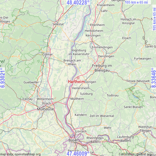
Hartheim GPS coordinates[2]
47° 55' 59.988" North, 7° 37' 59.988" East
| Map corner | latitude | longitude |
|---|---|---|
| Upper-left | 48.40228°, | 6.93021° |
| Center: | 47.93333°, | 7.63333° |
| Lower-right: | 47.46009°, | 8.33646° |
| Map W x H: | 104.8×104.8 km | = 65.1×65.1mi |
| max Lat: | 55.01917° ⇑96.3% North |
| Hartheim: | 47.93333° |
| min Lat: | ⇓3.7% South 47.40724° |
| min Long | Hartheim | max Long |
| 5.92978° | 7.63333° | 14.98853° |
| W 15.6%⇐ | ⇒84.4% E |
Elevation
Elevation of Hartheim is 201 m = 659 ft, and this is 48.1 m = 158 ft below average elevation for this country.
| Max E: |
1256 m = 4121 ft | 53.4% |
| Avg. | 249.1 m = 817 ft | |
| Hartheim | 201 m = 659 ft | |
Min E: |
-5 m = -16 ft | 46.6% |
See also: Germany elevation on elevation.city.
Geographical zone
Hartheim is located in North temperate zone (between Tropic of Cancer and the Arctic Circle). Distance of this North polar circle is 2071.5 km =1287.2 mi to North.| Distance of | km | miles | from Hartheim |
|---|---|---|---|
| North Pole | 4677.4 | 2906.4 | to North |
| Arctic Circle | 2071.5 | 1287.2 | to North |
| Tropic Cancer | 2723.8 | 1692.5 | to South |
| Equator | 5329.7 | 3311.7 | to South |


Nearby cities:
15 places around Hartheim: (largest is in red/bold)
• Bad Krozingen
5.3 km =3.3 mi,  110°
110°
• Bollschweil
11.7 km =7.3 mi,  96°
96°
• Breisach am Rhein
11.7 km =7.3 mi,  341°
341°
• Buggingen
9.5 km =5.9 mi,  177°
177°
• Ebringen
11 km =6.8 mi,  75°
75°
• Eschbach
5 km =3.1 mi,  160°
160°
• Heitersheim
6.8 km =4.2 mi, 164°
• Ihringen
12.2 km =7.6 mi,  4°
4°
• Merdingen
10 km =6.2 mi,  21°
21°
• Pfaffenweiler
8.7 km =5.4 mi,  90°
90°
• Schallstadt
9.7 km =6 mi,  73°
73°
• Sulzburg
11.7 km =7.3 mi,  151°
151°
• Sölden
13.7 km =8.5 mi, 90°
• Unterkrozingen
4.5 km =2.8 mi, 110°
• Wittnau
13.8 km =8.6 mi, 82°
Sources, notices
• [Note1] Compared only with cities in Germany existing in our database
• [Src1] Map data: © OpenStreetMap contributors (CC-BY-SA)
• [Src2] Other city data from geonames.org with taken over terms of usage.
• [Src3] Geographical zone / Annual Mean Temperature by Robert A. Rohde @ Wikipedia
