Unterkrozingen geodata
Unterkrozingen (Baden-Württemberg) is a section of populated place; located in Germany in Europe/Berlin (GMT+2) time zone. With population of 15,908 people, there are 1012 cities with bigger population in this country. Compared to other cities in Germany, 96.4% of cities are located further ↑North; 83.2% of cities are located further →East and 50.2% of cities have higher elevation than Unterkrozingen. Note1
Administrative division(s):
- Level 1: Baden-Württemberg
- Level 2: Freiburg Region
- Level 3: Landkreis Breisgau-Hochschwarzwald
- Level 4: Bad Krozingen


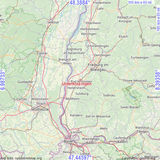
Unterkrozingen GPS coordinates[2]
47° 55' 9.588" North, 7° 41' 25.62" East
| Map corner | latitude | longitude |
|---|---|---|
| Upper-left | 48.3884°, | 6.98733° |
| Center: | 47.91933°, | 7.69045° |
| Lower-right: | 47.44597°, | 8.39358° |
| Map W x H: | 104.8×104.8 km | = 65.1×65.1mi |
| max Lat: | 55.01917° ⇑96.4% North |
| Unterkrozingen: | 47.91933° |
| min Lat: | ⇓3.6% South 47.40724° |
| min Long | Unterkrozingen | max Long |
| 5.92978° | 7.69045° | 14.98853° |
| W 16.8%⇐ | ⇒83.2% E |
Elevation
Elevation of Unterkrozingen is 224 m = 735 ft, and this is 25.1 m = 82 ft below average elevation for this country.
| Max E: |
1256 m = 4121 ft | 50.2% |
| Avg. | 249.1 m = 817 ft | |
| Unterkrozingen | 224 m = 735 ft | |
Min E: |
-5 m = -16 ft | 49.8% |
See also: Germany elevation on elevation.city.
Geographical zone
Unterkrozingen is located in North temperate zone (between Tropic of Cancer and the Arctic Circle). Distance of this North polar circle is 2073 km =1288.1 mi to North.| Distance of | km | miles | from Unterkrozingen |
|---|---|---|---|
| North Pole | 4678.9 | 2907.3 | to North |
| Arctic Circle | 2073 | 1288.1 | to North |
| Tropic Cancer | 2722.2 | 1691.5 | to South |
| Equator | 5328.1 | 3310.7 | to South |


Nearby cities:
15 places around Unterkrozingen: (largest is in red/bold)
• Au
11.2 km =7 mi,  72°
72°
• Bad Krozingen
0.8 km =0.5 mi,  112°
112°
• Bollschweil
7.4 km =4.6 mi,  88°
88°
• Buggingen
8.9 km =5.5 mi,  206°
206°
• Ebringen
7.7 km =4.8 mi,  56°
56°
• Eschbach
4.1 km =2.5 mi,  219°
219°
• Hartheim
4.5 km =2.8 mi,  290°
290°
• Heitersheim
5.5 km =3.4 mi, 206°
• Merdingen
10.8 km =6.7 mi,  357°
357°
• Münstertal/Schwarzwald
10 km =6.2 mi,  135°
135°
• Pfaffenweiler
4.7 km =2.9 mi, 70°
• Schallstadt
6.6 km =4.1 mi,  48°
48°
• Sulzburg
8.8 km =5.5 mi,  171°
171°
• Sölden
9.5 km =5.9 mi,  80°
80°
• Wittnau
10 km =6.2 mi, 70°
Sources, notices
• [Note1] Compared only with cities in Germany existing in our database
• [Src1] Map data: © OpenStreetMap contributors (CC-BY-SA)
• [Src2] Other city data from geonames.org with taken over terms of usage.
• [Src3] Geographical zone / Annual Mean Temperature by Robert A. Rohde @ Wikipedia
