Schallstadt geodata
Schallstadt (Baden-Württemberg) is a seat of a fourth-order administrative division; located in Germany in Europe/Berlin (GMT+2) time zone. With population of 5,841 people, there are 2510 cities with bigger population in this country. Compared to other cities in Germany, 95.9% of cities are located further ↑North; 81.9% of cities are located further →East and 50.3% of cities have higher elevation than Schallstadt. Note1
Administrative division(s):
- Level 1: Baden-Württemberg
- Level 2: Freiburg Region
- Level 3: Landkreis Breisgau-Hochschwarzwald
- Level 4: Schallstadt


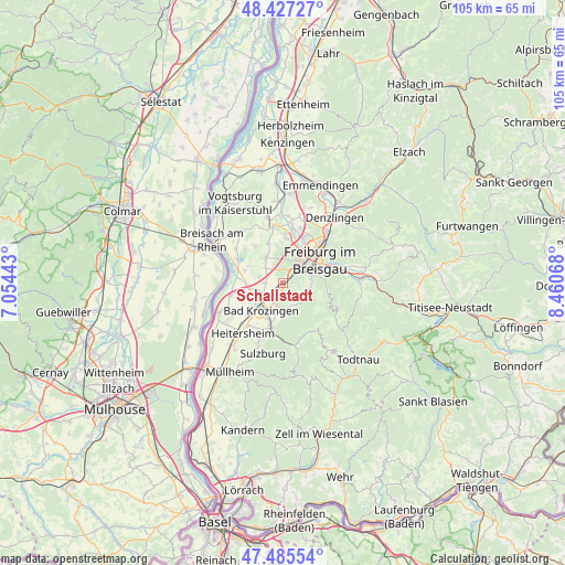
Schallstadt GPS coordinates[2]
47° 57' 30.78" North, 7° 45' 27.18" East
| Map corner | latitude | longitude |
|---|---|---|
| Upper-left | 48.42727°, | 7.05443° |
| Center: | 47.95855°, | 7.75755° |
| Lower-right: | 47.48554°, | 8.46068° |
| Map W x H: | 104.7×104.7 km | = 65.1×65.1mi |
| max Lat: | 55.01917° ⇑95.9% North |
| Schallstadt: | 47.95855° |
| min Lat: | ⇓4.1% South 47.40724° |
| min Long | Schallstadt | max Long |
| 5.92978° | 7.75755° | 14.98853° |
| W 18.1%⇐ | ⇒81.9% E |
Elevation
Elevation of Schallstadt is 223 m = 732 ft, and this is 26.1 m = 86 ft below average elevation for this country.
| Max E: |
1256 m = 4121 ft | 50.3% |
| Avg. | 249.1 m = 817 ft | |
| Schallstadt | 223 m = 732 ft | |
Min E: |
-5 m = -16 ft | 49.7% |
See also: Germany elevation on elevation.city.
Geographical zone
Schallstadt is located in North temperate zone (between Tropic of Cancer and the Arctic Circle). Distance of this North polar circle is 2068.7 km =1285.4 mi to North.| Distance of | km | miles | from Schallstadt |
|---|---|---|---|
| North Pole | 4674.6 | 2904.7 | to North |
| Arctic Circle | 2068.7 | 1285.4 | to North |
| Tropic Cancer | 2726.6 | 1694.2 | to South |
| Equator | 5332.5 | 3313.5 | to South |


Nearby cities:
15 places around Schallstadt: (largest is in red/bold)
• Au
5.7 km =3.5 mi,  99°
99°
• Bad Krozingen
6.3 km =3.9 mi,  222°
222°
• Bollschweil
4.8 km =3 mi,  149°
149°
• Ebringen
1.4 km =0.9 mi,  93°
93°
• Freiburg
8.2 km =5.1 mi,  59°
59°
• Gottenheim
10.3 km =6.4 mi,  349°
349°
• Hartheim
9.7 km =6 mi,  253°
253°
• Horben
8.6 km =5.3 mi,  109°
109°
• Merdingen
8.5 km =5.3 mi,  319°
319°
• Merzhausen
5.7 km =3.5 mi,  80°
80°
• Pfaffenweiler
2.9 km =1.8 mi,  191°
191°
• Sölden
5.2 km =3.2 mi,  122°
122°
• Umkirch
8.3 km =5.2 mi,  4°
4°
• Unterkrozingen
6.6 km =4.1 mi,  228°
228°
• Wittnau
4.5 km =2.8 mi, 102°
Sources, notices
• [Note1] Compared only with cities in Germany existing in our database
• [Src1] Map data: © OpenStreetMap contributors (CC-BY-SA)
• [Src2] Other city data from geonames.org with taken over terms of usage.
• [Src3] Geographical zone / Annual Mean Temperature by Robert A. Rohde @ Wikipedia
