Halstenbek geodata
Halstenbek (Schleswig-Holstein) is a seat of a fourth-order administrative division; located in Germany in Europe/Berlin (GMT+2) time zone. With population of 16,212 people, there are 981 cities with bigger population in this country. Compared to other cities in Germany, 87.5% of cities are located further ↓South; 52.2% of cities are located further →East and 92.3% of cities have higher elevation than Halstenbek. Note1
Administrative division(s):
- Level 1: Schleswig-Holstein
- Level 3: Kreis Pinneberg
- Level 4: Halstenbek


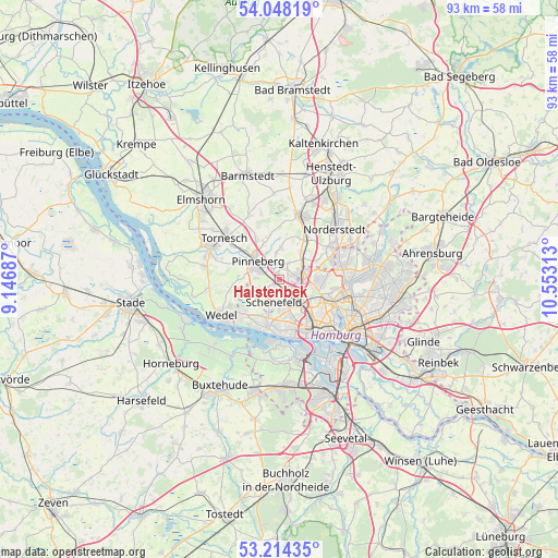
Halstenbek GPS coordinates[2]
53° 37' 59.988" North, 9° 51' 0" East
| Map corner | latitude | longitude |
|---|---|---|
| Upper-left | 54.04819°, | 9.14687° |
| Center: | 53.63333°, | 9.85° |
| Lower-right: | 53.21435°, | 10.55313° |
| Map W x H: | 92.7×92.7 km | = 57.6×57.6mi |
| max Lat: | 55.01917° ⇑12.5% North |
| Halstenbek: | 53.63333° |
| min Lat: | ⇓87.5% South 47.40724° |
| min Long | Halstenbek | max Long |
| 5.92978° | 9.85° | 14.98853° |
| W 47.8%⇐ | ⇒52.2% E |
Elevation
Elevation of Halstenbek is 15 m = 49 ft, and this is 234.1 m = 768 ft below average elevation for this country.
| Max E: |
1256 m = 4121 ft | 92.3% |
| Avg. | 249.1 m = 817 ft | |
| Halstenbek | 15 m = 49 ft | |
Min E: |
-5 m = -16 ft | 7.7% |
See also: Germany elevation on elevation.city.
Geographical zone
Halstenbek is located in North temperate zone (between Tropic of Cancer and the Arctic Circle). Distance of this North polar circle is 1437.7 km =893.3 mi to North.| Distance of | km | miles | from Halstenbek |
|---|---|---|---|
| North Pole | 4043.6 | 2512.6 | to North |
| Arctic Circle | 1437.7 | 893.3 | to North |
| Tropic Cancer | 3357.5 | 2086.3 | to South |
| Equator | 5963.5 | 3705.5 | to South |


Nearby cities:
15 places around Halstenbek: (largest is in red/bold)
• Appen
7.4 km =4.6 mi,  291°
291°
• Borstel-Hohenraden
6 km =3.7 mi,  338°
338°
• Bönningstedt
5.7 km =3.5 mi,  49°
49°
• Eidelstedt
4.7 km =2.9 mi,  128°
128°
• Eimsbüttel
9.6 km =6 mi, 133°
• Ellerbek
3.1 km =1.9 mi,  25°
25°
• Hamburg-Nord
10.1 km =6.3 mi,  118°
118°
• Hasloh
8.1 km =5 mi, 32°
• Kummerfeld
7.7 km =4.8 mi,  329°
329°
• Lurup
4.9 km =3 mi,  158°
158°
• Pinneberg
5.5 km =3.4 mi,  313°
313°
• Prisdorf
8.6 km =5.3 mi, 310°
• Rellingen
2.9 km =1.8 mi, 310°
• Stellingen
6.9 km =4.3 mi, 131°
• Tangstedt
4.9 km =3 mi,  359°
359°
Sources, notices
• [Note1] Compared only with cities in Germany existing in our database
• [Src1] Map data: © OpenStreetMap contributors (CC-BY-SA)
• [Src2] Other city data from geonames.org with taken over terms of usage.
• [Src3] Geographical zone / Annual Mean Temperature by Robert A. Rohde @ Wikipedia
