Haibach geodata
Haibach (Bavaria) is a seat of a fourth-order administrative division; located in Germany in Europe/Berlin (GMT+2) time zone. With population of 8,600 people, there are 1859 cities with bigger population in this country. Compared to other cities in Germany, 64.8% of cities are located further ↑North; 62.3% of cities are located further →East and 58.1% of cities have lower elevation than Haibach. Note1
Administrative division(s):
- Level 1: Bavaria
- Level 2: Regierungsbezirk Unterfranken
- Level 3: Landkreis Aschaffenburg
- Level 4: Haibach


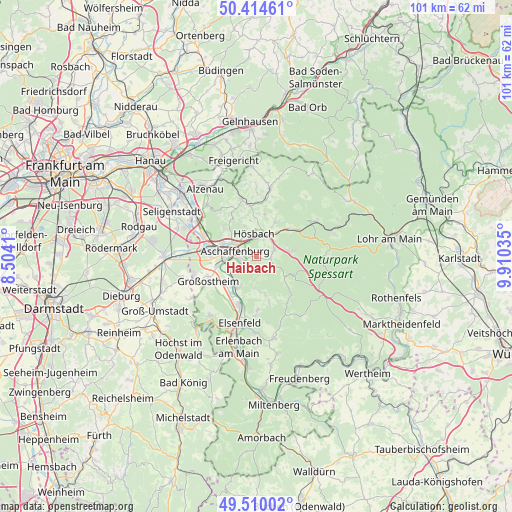
Haibach GPS coordinates[2]
49° 57' 51.984" North, 9° 12' 25.992" East
| Map corner | latitude | longitude |
|---|---|---|
| Upper-left | 50.41461°, | 8.5041° |
| Center: | 49.96444°, | 9.20722° |
| Lower-right: | 49.51002°, | 9.91035° |
| Map W x H: | 100.6×100.6 km | = 62.5×62.5mi |
| max Lat: | 55.01917° ⇑64.8% North |
| Haibach: | 49.96444° |
| min Lat: | ⇓35.2% South 47.40724° |
| min Long | Haibach | max Long |
| 5.92978° | 9.20722° | 14.98853° |
| W 37.7%⇐ | ⇒62.3% E |
Elevation
Elevation of Haibach is 279 m = 915 ft, and this is 29.9 m = 98 ft above average elevation for this country.
| Max E: |
1256 m = 4121 ft | 41.9% |
| Haibach | 279 m 915 ft | |
| Avg. | 249.1 m = 817 ft | |
Min E: |
-5 m = -16 ft | 58.1% |
See also: Germany elevation on elevation.city.
Geographical zone
Haibach is located in North temperate zone (between Tropic of Cancer and the Arctic Circle). Distance of this North polar circle is 1845.6 km =1146.8 mi to North.| Distance of | km | miles | from Haibach |
|---|---|---|---|
| North Pole | 4451.5 | 2766 | to North |
| Arctic Circle | 1845.6 | 1146.8 | to North |
| Tropic Cancer | 2949.6 | 1832.8 | to South |
| Equator | 5555.5 | 3452 | to South |


Nearby cities:
15 places around Haibach: (largest is in red/bold)
• Aschaffenburg
4.2 km =2.6 mi,  289°
289°
• Glattbach
5.7 km =3.5 mi,  314°
314°
• Goldbach
4.2 km =2.6 mi,  337°
337°
• Großwallstadt
10.2 km =6.3 mi,  202°
202°
• Hösbach
4.7 km =2.9 mi,  0°
0°
• Johannesberg
8.8 km =5.5 mi,  328°
328°
• Laufach
8.8 km =5.5 mi,  48°
48°
• Leidersbach
7.1 km =4.4 mi,  171°
171°
• Mainaschaff
8.6 km =5.3 mi,  282°
282°
• Mespelbrunn
8.2 km =5.1 mi,  132°
132°
• Niedernberg
7.7 km =4.8 mi,  220°
220°
• Sailauf
7.7 km =4.8 mi,  29°
29°
• Stockstadt am Main
9.7 km =6 mi,  273°
273°
• Sulzbach am Main
7 km =4.3 mi,  213°
213°
• Waldaschaff
6.9 km =4.3 mi,  79°
79°
Sources, notices
• [Note1] Compared only with cities in Germany existing in our database
• [Src1] Map data: © OpenStreetMap contributors (CC-BY-SA)
• [Src2] Other city data from geonames.org with taken over terms of usage.
• [Src3] Geographical zone / Annual Mean Temperature by Robert A. Rohde @ Wikipedia
