Niedernberg geodata
Niedernberg (Bavaria) is a seat of a fourth-order administrative division; located in Germany in Europe/Berlin (GMT+2) time zone. With population of 4,793 people, there are 2904 cities with bigger population in this country. Compared to other cities in Germany, 66.1% of cities are located further ↑North; 63.4% of cities are located further →East and 64.7% of cities have higher elevation than Niedernberg. Note1
Administrative division(s):
- Level 1: Bavaria
- Level 2: Regierungsbezirk Unterfranken
- Level 3: Landkreis Miltenberg
- Level 4: Niedernberg


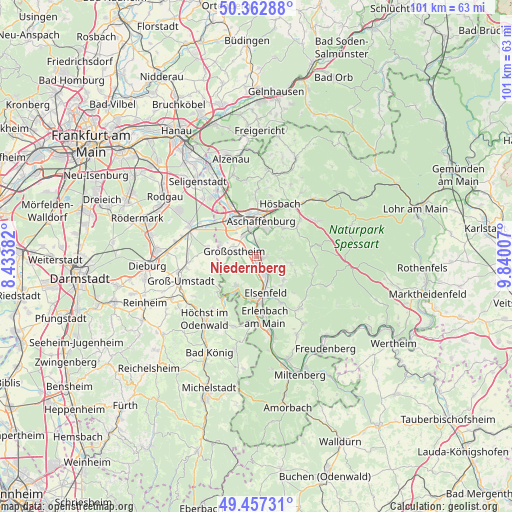
Niedernberg GPS coordinates[2]
49° 54' 43.992" North, 9° 8' 12.984" East
| Map corner | latitude | longitude |
|---|---|---|
| Upper-left | 50.36288°, | 8.43382° |
| Center: | 49.91222°, | 9.13694° |
| Lower-right: | 49.45731°, | 9.84007° |
| Map W x H: | 100.7×100.7 km | = 62.6×62.6mi |
| max Lat: | 55.01917° ⇑66.1% North |
| Niedernberg: | 49.91222° |
| min Lat: | ⇓33.9% South 47.40724° |
| min Long | Niedernberg | max Long |
| 5.92978° | 9.13694° | 14.98853° |
| W 36.6%⇐ | ⇒63.4% E |
Elevation
Elevation of Niedernberg is 122 m = 400 ft, and this is 127.1 m = 417 ft below average elevation for this country.
| Max E: |
1256 m = 4121 ft | 64.7% |
| Avg. | 249.1 m = 817 ft | |
| Niedernberg | 122 m = 400 ft | |
Min E: |
-5 m = -16 ft | 35.3% |
See also: Germany elevation on elevation.city.
Geographical zone
Niedernberg is located in North temperate zone (between Tropic of Cancer and the Arctic Circle). Distance of this North polar circle is 1851.5 km =1150.5 mi to North.| Distance of | km | miles | from Niedernberg |
|---|---|---|---|
| North Pole | 4457.3 | 2769.6 | to North |
| Arctic Circle | 1851.5 | 1150.5 | to North |
| Tropic Cancer | 2943.8 | 1829.2 | to South |
| Equator | 5549.7 | 3448.4 | to South |


Nearby cities:
15 places around Niedernberg: (largest is in red/bold)
• Aschaffenburg
7.3 km =4.5 mi,  8°
8°
• Elsenfeld
7.9 km =4.9 mi,  166°
166°
• Glattbach
9.8 km =6.1 mi, 5°
• Großostheim
4.4 km =2.7 mi,  280°
280°
• Großwallstadt
3.8 km =2.4 mi,  162°
162°
• Haibach
7.7 km =4.8 mi,  40°
40°
• Hausen
7.1 km =4.4 mi,  131°
131°
• Kleinwallstadt
4.8 km =3 mi,  151°
151°
• Leidersbach
6.2 km =3.9 mi,  101°
101°
• Mainaschaff
8.4 km =5.2 mi,  336°
336°
• Mömlingen
7 km =4.3 mi,  213°
213°
• Obernburg am Main
8.5 km =5.3 mi,  182°
182°
• Schaafheim
9.2 km =5.7 mi, 278°
• Stockstadt am Main
8 km =5 mi,  323°
323°
• Sulzbach am Main
1.2 km =0.7 mi,  94°
94°
Sources, notices
• [Note1] Compared only with cities in Germany existing in our database
• [Src1] Map data: © OpenStreetMap contributors (CC-BY-SA)
• [Src2] Other city data from geonames.org with taken over terms of usage.
• [Src3] Geographical zone / Annual Mean Temperature by Robert A. Rohde @ Wikipedia
