Mainaschaff geodata
Mainaschaff (Bavaria) is a seat of a fourth-order administrative division; located in Germany in Europe/Berlin (GMT+2) time zone. With population of 8,382 people, there are 1893 cities with bigger population in this country. Compared to other cities in Germany, 64.3% of cities are located further ↑North; 64.2% of cities are located further →East and 65.2% of cities have higher elevation than Mainaschaff. Note1
Administrative division(s):
- Level 1: Bavaria
- Level 2: Regierungsbezirk Unterfranken
- Level 3: Landkreis Aschaffenburg
- Level 4: Mainaschaff


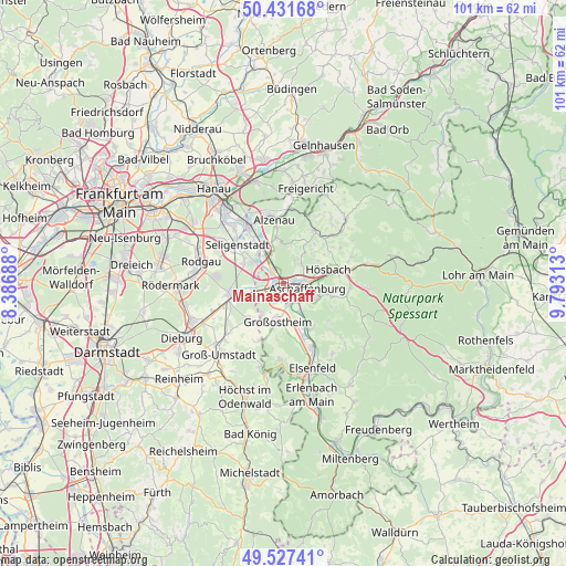
Mainaschaff GPS coordinates[2]
49° 58' 54.012" North, 9° 5' 24" East
| Map corner | latitude | longitude |
|---|---|---|
| Upper-left | 50.43168°, | 8.38688° |
| Center: | 49.98167°, | 9.09° |
| Lower-right: | 49.52741°, | 9.79313° |
| Map W x H: | 100.5×100.5 km | = 62.4×62.4mi |
| max Lat: | 55.01917° ⇑64.3% North |
| Mainaschaff: | 49.98167° |
| min Lat: | ⇓35.7% South 47.40724° |
| min Long | Mainaschaff | max Long |
| 5.92978° | 9.09° | 14.98853° |
| W 35.8%⇐ | ⇒64.2% E |
Elevation
Elevation of Mainaschaff is 119 m = 390 ft, and this is 130.1 m = 427 ft below average elevation for this country.
| Max E: |
1256 m = 4121 ft | 65.2% |
| Avg. | 249.1 m = 817 ft | |
| Mainaschaff | 119 m = 390 ft | |
Min E: |
-5 m = -16 ft | 34.8% |
See also: Germany elevation on elevation.city.
Geographical zone
Mainaschaff is located in North temperate zone (between Tropic of Cancer and the Arctic Circle). Distance of this North polar circle is 1843.7 km =1145.6 mi to North.| Distance of | km | miles | from Mainaschaff |
|---|---|---|---|
| North Pole | 4449.6 | 2764.9 | to North |
| Arctic Circle | 1843.7 | 1145.6 | to North |
| Tropic Cancer | 2951.5 | 1834 | to South |
| Equator | 5557.4 | 3453.2 | to South |


Nearby cities:
15 places around Mainaschaff: (largest is in red/bold)
• Aschaffenburg
4.5 km =2.8 mi,  96°
96°
• Babenhausen
10.1 km =6.3 mi,  259°
259°
• Glattbach
4.7 km =2.9 mi,  64°
64°
• Goldbach
7 km =4.3 mi,  73°
73°
• Großostheim
6.9 km =4.3 mi,  188°
188°
• Haibach
8.6 km =5.3 mi, 102°
• Hösbach
8.8 km =5.5 mi, 71°
• Johannesberg
6.7 km =4.2 mi,  34°
34°
• Kleinostheim
2.6 km =1.6 mi,  320°
320°
• Mömbris
11.1 km =6.9 mi, 28°
• Niedernberg
8.4 km =5.2 mi,  156°
156°
• Schaafheim
8.6 km =5.3 mi,  222°
222°
• Seligenstadt
10.8 km =6.7 mi,  309°
309°
• Stockstadt am Main
1.8 km =1.1 mi,  225°
225°
• Sulzbach am Main
9 km =5.6 mi,  149°
149°
Sources, notices
• [Note1] Compared only with cities in Germany existing in our database
• [Src1] Map data: © OpenStreetMap contributors (CC-BY-SA)
• [Src2] Other city data from geonames.org with taken over terms of usage.
• [Src3] Geographical zone / Annual Mean Temperature by Robert A. Rohde @ Wikipedia
