Groß-Gerau geodata
Groß-Gerau (Hesse) is a seat of a third-order administrative division; located in Germany in Europe/Berlin (GMT+2) time zone. With population of 23,641 people, there are 632 cities with bigger population in this country. Compared to other cities in Germany, 65.8% of cities are located further ↑North; 71.3% of cities are located further →East and 69.4% of cities have higher elevation than Groß-Gerau. Note1
Administrative division(s):
- Level 1: Hesse
- Level 2: Regierungsbezirk Darmstadt
- Level 3: Landkreis Groß-Gerau
- Level 4: Groß-Gerau


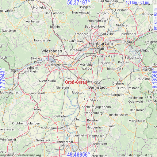
Groß-Gerau GPS coordinates[2]
49° 55' 17.004" North, 8° 28' 57.18" East
| Map corner | latitude | longitude |
|---|---|---|
| Upper-left | 50.37197°, | 7.77943° |
| Center: | 49.92139°, | 8.48255° |
| Lower-right: | 49.46656°, | 9.18568° |
| Map W x H: | 100.7×100.7 km | = 62.6×62.6mi |
| max Lat: | 55.01917° ⇑65.8% North |
| Groß-Gerau: | 49.92139° |
| min Lat: | ⇓34.2% South 47.40724° |
| min Long | Groß-Gerau | max Long |
| 5.92978° | 8.48255° | 14.98853° |
| W 28.7%⇐ | ⇒71.3% E |
Elevation
Elevation of Groß-Gerau is 95 m = 312 ft, and this is 154.1 m = 506 ft below average elevation for this country.
| Max E: |
1256 m = 4121 ft | 69.4% |
| Avg. | 249.1 m = 817 ft | |
| Groß-Gerau | 95 m = 312 ft | |
Min E: |
-5 m = -16 ft | 30.6% |
See also: Germany elevation on elevation.city.
Geographical zone
Groß-Gerau is located in North temperate zone (between Tropic of Cancer and the Arctic Circle). Distance of this North polar circle is 1850.4 km =1149.8 mi to North.| Distance of | km | miles | from Groß-Gerau |
|---|---|---|---|
| North Pole | 4456.3 | 2769 | to North |
| Arctic Circle | 1850.4 | 1149.8 | to North |
| Tropic Cancer | 2944.8 | 1829.8 | to South |
| Equator | 5550.7 | 3449 | to South |


Nearby cities:
15 places around Groß-Gerau: (largest is in red/bold)
• Bischofsheim
11.5 km =7.1 mi,  314°
314°
• Bodenheim
11.7 km =7.3 mi,  277°
277°
• Büttelborn
3.5 km =2.2 mi,  124°
124°
• Flörsheim
10.9 km =6.8 mi,  338°
338°
• Ginsheim-Gustavsburg
11.3 km =7 mi,  299°
299°
• Griesheim
9.3 km =5.8 mi,  136°
136°
• Mörfelden-Walldorf
10.9 km =6.8 mi,  41°
41°
• Nackenheim
10.3 km =6.4 mi,  266°
266°
• Nauheim
3.6 km =2.2 mi, 337°
• Oppenheim
11.5 km =7.1 mi,  229°
229°
• Raunheim
10.4 km =6.5 mi,  348°
348°
• Riedstadt
9.8 km =6.1 mi,  174°
174°
• Rüsselsheim
8.7 km =5.4 mi,  330°
330°
• Trebur
5.4 km =3.4 mi, 275°
• Weiterstadt
7.8 km =4.8 mi,  104°
104°
Sources, notices
• [Note1] Compared only with cities in Germany existing in our database
• [Src1] Map data: © OpenStreetMap contributors (CC-BY-SA)
• [Src2] Other city data from geonames.org with taken over terms of usage.
• [Src3] Geographical zone / Annual Mean Temperature by Robert A. Rohde @ Wikipedia
