Büttelborn geodata
Büttelborn (Hesse) is a seat of a fourth-order administrative division; located in Germany in Europe/Berlin (GMT+2) time zone. With population of 13,338 people, there are 1198 cities with bigger population in this country. Compared to other cities in Germany, 66.3% of cities are located further ↑North; 70.9% of cities are located further →East and 69.4% of cities have higher elevation than Büttelborn. Note1
Administrative division(s):
- Level 1: Hesse
- Level 2: Regierungsbezirk Darmstadt
- Level 3: Landkreis Groß-Gerau
- Level 4: Büttelborn


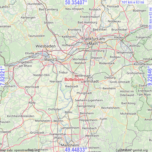
Büttelborn GPS coordinates[2]
49° 54' 11.988" North, 8° 31' 23.988" East
| Map corner | latitude | longitude |
|---|---|---|
| Upper-left | 50.35407°, | 7.82021° |
| Center: | 49.90333°, | 8.52333° |
| Lower-right: | 49.44833°, | 9.22646° |
| Map W x H: | 100.7×100.7 km | = 62.6×62.6mi |
| max Lat: | 55.01917° ⇑66.3% North |
| Büttelborn: | 49.90333° |
| min Lat: | ⇓33.7% South 47.40724° |
| min Long | Büttelborn | max Long |
| 5.92978° | 8.52333° | 14.98853° |
| W 29.1%⇐ | ⇒70.9% E |
Elevation
Elevation of Büttelborn is 95 m = 312 ft, and this is 154.1 m = 506 ft below average elevation for this country.
| Max E: |
1256 m = 4121 ft | 69.4% |
| Avg. | 249.1 m = 817 ft | |
| Büttelborn | 95 m = 312 ft | |
Min E: |
-5 m = -16 ft | 30.6% |
See also: Germany elevation on elevation.city.
Geographical zone
Büttelborn is located in North temperate zone (between Tropic of Cancer and the Arctic Circle). Distance of this North polar circle is 1852.4 km =1151 mi to North.| Distance of | km | miles | from Büttelborn |
|---|---|---|---|
| North Pole | 4458.3 | 2770.3 | to North |
| Arctic Circle | 1852.4 | 1151 | to North |
| Tropic Cancer | 2942.8 | 1828.6 | to South |
| Equator | 5548.7 | 3447.8 | to South |


Nearby cities:
15 places around Büttelborn: (largest is in red/bold)
• Darmstadt
9.8 km =6.1 mi,  111°
111°
• Egelsbach
12.3 km =7.6 mi,  54°
54°
• Erzhausen
10.6 km =6.6 mi,  56°
56°
• Griesheim
5.9 km =3.7 mi,  143°
143°
• Groß-Gerau
3.5 km =2.2 mi,  304°
304°
• Mörfelden-Walldorf
11 km =6.8 mi,  22°
22°
• Nauheim
6.8 km =4.2 mi,  320°
320°
• Oppenheim
12.9 km =8 mi,  245°
245°
• Pfungstadt
12.3 km =7.6 mi,  152°
152°
• Raunheim
13.2 km =8.2 mi,  337°
337°
• Riedstadt
7.9 km =4.9 mi,  194°
194°
• Rüsselsheim
12 km =7.5 mi, 323°
• Stockstadt am Rhein
11.1 km =6.9 mi,  199°
199°
• Trebur
8.7 km =5.4 mi,  287°
287°
• Weiterstadt
4.7 km =2.9 mi,  89°
89°
Sources, notices
• [Note1] Compared only with cities in Germany existing in our database
• [Src1] Map data: © OpenStreetMap contributors (CC-BY-SA)
• [Src2] Other city data from geonames.org with taken over terms of usage.
• [Src3] Geographical zone / Annual Mean Temperature by Robert A. Rohde @ Wikipedia
