Oppenheim geodata
Oppenheim (Rheinland-Pfalz) is a populated place; located in Germany in Europe/Berlin (GMT+2) time zone. With population of 6,789 people, there are 2239 cities with bigger population in this country. Compared to other cities in Germany, 67.7% of cities are located further ↑North; 72.3% of cities are located further →East and 70.5% of cities have higher elevation than Oppenheim. Note1
Administrative division(s):
- Level 1: Rheinland-Pfalz
- Level 3: Landkreis Mainz-Bingen
- Level 4: Oppenheim


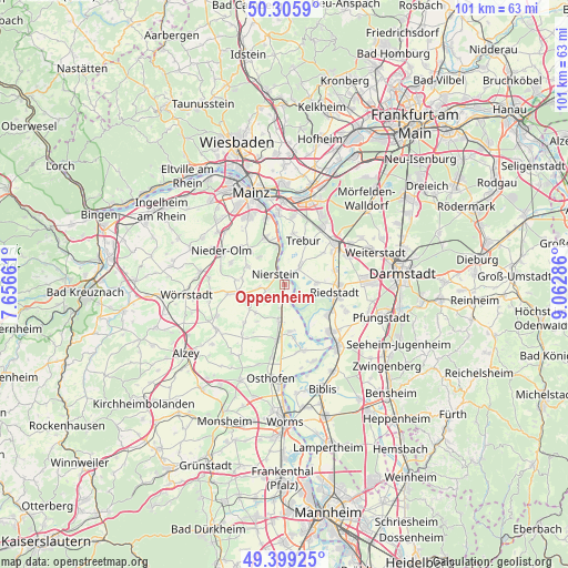
Oppenheim GPS coordinates[2]
49° 51' 16.92" North, 8° 21' 35.064" East
| Map corner | latitude | longitude |
|---|---|---|
| Upper-left | 50.3059°, | 7.65661° |
| Center: | 49.8547°, | 8.35974° |
| Lower-right: | 49.39925°, | 9.06286° |
| Map W x H: | 100.8×100.8 km | = 62.6×62.6mi |
| max Lat: | 55.01917° ⇑67.7% North |
| Oppenheim: | 49.8547° |
| min Lat: | ⇓32.3% South 47.40724° |
| min Long | Oppenheim | max Long |
| 5.92978° | 8.35974° | 14.98853° |
| W 27.7%⇐ | ⇒72.3% E |
Elevation
Elevation of Oppenheim is 88 m = 289 ft, and this is 161.1 m = 529 ft below average elevation for this country.
| Max E: |
1256 m = 4121 ft | 70.5% |
| Avg. | 249.1 m = 817 ft | |
| Oppenheim | 88 m = 289 ft | |
Min E: |
-5 m = -16 ft | 29.5% |
See also: Germany elevation on elevation.city.
Geographical zone
Oppenheim is located in North temperate zone (between Tropic of Cancer and the Arctic Circle). Distance of this North polar circle is 1857.9 km =1154.4 mi to North.| Distance of | km | miles | from Oppenheim |
|---|---|---|---|
| North Pole | 4463.7 | 2773.6 | to North |
| Arctic Circle | 1857.9 | 1154.4 | to North |
| Tropic Cancer | 2937.4 | 1825.2 | to South |
| Equator | 5543.3 | 3444.4 | to South |


Nearby cities:
15 places around Oppenheim: (largest is in red/bold)
• Dalheim
5.6 km =3.5 mi,  236°
236°
• Dexheim
3.2 km =2 mi,  254°
254°
• Dienheim
2.1 km =1.3 mi,  200°
200°
• Eimsheim
8.3 km =5.2 mi,  217°
217°
• Friesenheim
7.6 km =4.7 mi, 254°
• Guntersblum
6.4 km =4 mi,  189°
189°
• Köngernheim
8.2 km =5.1 mi,  263°
263°
• Ludwigshöhe
4.4 km =2.7 mi, 195°
• Lörzweiler
6.7 km =4.2 mi,  316°
316°
• Mommenheim
7.4 km =4.6 mi,  292°
292°
• Nackenheim
6.9 km =4.3 mi,  347°
347°
• Nierstein
2.4 km =1.5 mi, 315°
• Selzen
7.5 km =4.7 mi,  274°
274°
• Uelversheim
7.1 km =4.4 mi,  225°
225°
• Weinolsheim
7.6 km =4.7 mi, 235°
Sources, notices
• [Note1] Compared only with cities in Germany existing in our database
• [Src1] Map data: © OpenStreetMap contributors (CC-BY-SA)
• [Src2] Other city data from geonames.org with taken over terms of usage.
• [Src3] Geographical zone / Annual Mean Temperature by Robert A. Rohde @ Wikipedia
