Großbardau geodata
Großbardau (Saxony) is a populated place; located in Germany in Europe/Berlin (GMT+2) time zone. With population of 1,787 people, there are 5367 cities with bigger population in this country. Compared to other cities in Germany, 61.7% of cities are located further ↓South; 89.8% of cities are located further ←West and 58.9% of cities have higher elevation than Großbardau. Note1


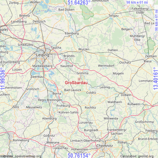
Großbardau GPS coordinates[2]
51° 12' 15.084" North, 12° 41' 54.528" East
| Map corner | latitude | longitude |
|---|---|---|
| Upper-left | 51.64263°, | 11.99536° |
| Center: | 51.20419°, | 12.69848° |
| Lower-right: | 50.76154°, | 13.40161° |
| Map W x H: | 98×98 km | = 60.9×60.9mi |
| max Lat: | 55.01917° ⇑38.3% North |
| Großbardau: | 51.20419° |
| min Lat: | ⇓61.7% South 47.40724° |
| min Long | Großbardau | max Long |
| 5.92978° | 12.69848° | 14.98853° |
| W 89.8%⇐ | ⇒10.2% E |
Elevation
Elevation of Großbardau is 161 m = 528 ft, and this is 88.1 m = 289 ft below average elevation for this country.
| Max E: |
1256 m = 4121 ft | 58.9% |
| Avg. | 249.1 m = 817 ft | |
| Großbardau | 161 m = 528 ft | |
Min E: |
-5 m = -16 ft | 41.1% |
See also: Germany elevation on elevation.city.
Geographical zone
Großbardau is located in North temperate zone (between Tropic of Cancer and the Arctic Circle). Distance of this North polar circle is 1707.8 km =1061.2 mi to North.| Distance of | km | miles | from Großbardau |
|---|---|---|---|
| North Pole | 4313.7 | 2680.4 | to North |
| Arctic Circle | 1707.8 | 1061.2 | to North |
| Tropic Cancer | 3087.5 | 1918.5 | to South |
| Equator | 5693.4 | 3537.7 | to South |


Nearby cities:
15 places around Großbardau: (largest is in red/bold)
• Bad Lausick
7.6 km =4.7 mi,  209°
209°
• Belgershain
10.8 km =6.7 mi,  287°
287°
• Colditz
11.2 km =7 mi,  139°
139°
• Espenhain
15.4 km =9.6 mi,  263°
263°
• Grimma
3.6 km =2.2 mi,  24°
24°
• Großbothen
4.1 km =2.5 mi,  116°
116°
• Großpösna
15.5 km =9.6 mi,  296°
296°
• Kitzscher
11.1 km =6.9 mi,  246°
246°
• Mutzschen
14.9 km =9.3 mi,  64°
64°
• Naunhof
11.2 km =7 mi,  316°
316°
• Nerchau
9.7 km =6 mi,  40°
40°
• Ostrau
12.9 km =8 mi,  88°
88°
• Otterwisch
5.7 km =3.5 mi,  265°
265°
• Trebsen
10.2 km =6.3 mi, 22°
• Zschadrass
11.1 km =6.9 mi,  131°
131°
Sources, notices
• [Note1] Compared only with cities in Germany existing in our database
• [Src1] Map data: © OpenStreetMap contributors (CC-BY-SA)
• [Src2] Other city data from geonames.org with taken over terms of usage.
• [Src3] Geographical zone / Annual Mean Temperature by Robert A. Rohde @ Wikipedia
