Zschadrass geodata
Zschadrass (Saxony) is a populated place; located in Germany in Europe/Berlin (GMT+2) time zone. With population of 3,763 people, there are 3432 cities with bigger population in this country. Compared to other cities in Germany, 60.6% of cities are located further ↓South; 90.9% of cities are located further ←West and 50.3% of cities have higher elevation than Zschadrass. Note1


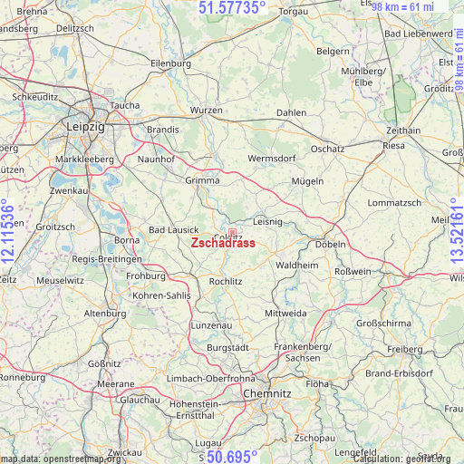
Zschadrass GPS coordinates[2]
51° 8' 17.808" North, 12° 49' 6.528" East
| Map corner | latitude | longitude |
|---|---|---|
| Upper-left | 51.57735°, | 12.11536° |
| Center: | 51.13828°, | 12.81848° |
| Lower-right: | 50.695°, | 13.52161° |
| Map W x H: | 98.1×98.1 km | = 61×61mi |
| max Lat: | 55.01917° ⇑39.4% North |
| Zschadrass: | 51.13828° |
| min Lat: | ⇓60.6% South 47.40724° |
| min Long | Zschadrass | max Long |
| 5.92978° | 12.81848° | 14.98853° |
| W 90.9%⇐ | ⇒9.1% E |
Elevation
Elevation of Zschadrass is 223 m = 732 ft, and this is 26.1 m = 86 ft below average elevation for this country.
| Max E: |
1256 m = 4121 ft | 50.3% |
| Avg. | 249.1 m = 817 ft | |
| Zschadrass | 223 m = 732 ft | |
Min E: |
-5 m = -16 ft | 49.7% |
See also: Germany elevation on elevation.city.
Geographical zone
Zschadrass is located in North temperate zone (between Tropic of Cancer and the Arctic Circle). Distance of this North polar circle is 1715.1 km =1065.7 mi to North.| Distance of | km | miles | from Zschadrass |
|---|---|---|---|
| North Pole | 4321 | 2684.9 | to North |
| Arctic Circle | 1715.1 | 1065.7 | to North |
| Tropic Cancer | 3080.1 | 1913.9 | to South |
| Equator | 5686 | 3533.1 | to South |


Nearby cities:
15 places around Zschadrass: (largest is in red/bold)
• Bad Lausick
12.2 km =7.6 mi,  273°
273°
• Bockelwitz
11.8 km =7.3 mi,  54°
54°
• Colditz
1.6 km =1 mi,  224°
224°
• Geithain
12.5 km =7.8 mi, 222°
• Geringswalde
9.2 km =5.7 mi,  137°
137°
• Gersdorf
8.9 km =5.5 mi,  109°
109°
• Großbardau
11.1 km =6.9 mi,  311°
311°
• Großbothen
7.2 km =4.5 mi,  319°
319°
• Hartha
11.7 km =7.3 mi, 112°
• Königsfeld
9.3 km =5.8 mi,  210°
210°
• Leisnig
7.9 km =4.9 mi,  74°
74°
• Ostrau
8.9 km =5.5 mi,  31°
31°
• Rochlitz
9.9 km =6.2 mi,  188°
188°
• Seelitz
11.7 km =7.3 mi,  180°
180°
• Zettlitz
8 km =5 mi,  172°
172°
Sources, notices
• [Note1] Compared only with cities in Germany existing in our database
• [Src1] Map data: © OpenStreetMap contributors (CC-BY-SA)
• [Src2] Other city data from geonames.org with taken over terms of usage.
• [Src3] Geographical zone / Annual Mean Temperature by Robert A. Rohde @ Wikipedia
