Kitzscher geodata
Kitzscher (Saxony) is a populated place; located in Germany in Europe/Berlin (GMT+2) time zone. With population of 6,152 people, there are 2414 cities with bigger population in this country. Compared to other cities in Germany, 61% of cities are located further ↓South; 88.4% of cities are located further ←West and 58.3% of cities have higher elevation than Kitzscher. Note1


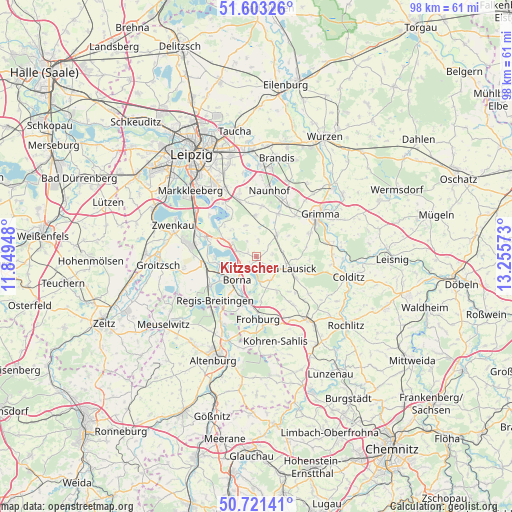
Kitzscher GPS coordinates[2]
51° 9' 51.984" North, 12° 33' 9.36" East
| Map corner | latitude | longitude |
|---|---|---|
| Upper-left | 51.60326°, | 11.84948° |
| Center: | 51.16444°, | 12.5526° |
| Lower-right: | 50.72141°, | 13.25573° |
| Map W x H: | 98.1×98.1 km | = 61×61mi |
| max Lat: | 55.01917° ⇑39% North |
| Kitzscher: | 51.16444° |
| min Lat: | ⇓61% South 47.40724° |
| min Long | Kitzscher | max Long |
| 5.92978° | 12.5526° | 14.98853° |
| W 88.4%⇐ | ⇒11.6% E |
Elevation
Elevation of Kitzscher is 165 m = 541 ft, and this is 84.1 m = 276 ft below average elevation for this country.
| Max E: |
1256 m = 4121 ft | 58.3% |
| Avg. | 249.1 m = 817 ft | |
| Kitzscher | 165 m = 541 ft | |
Min E: |
-5 m = -16 ft | 41.7% |
See also: Germany elevation on elevation.city.
Geographical zone
Kitzscher is located in North temperate zone (between Tropic of Cancer and the Arctic Circle). Distance of this North polar circle is 1712.2 km =1063.9 mi to North.| Distance of | km | miles | from Kitzscher |
|---|---|---|---|
| North Pole | 4318.1 | 2683.1 | to North |
| Arctic Circle | 1712.2 | 1063.9 | to North |
| Tropic Cancer | 3083 | 1915.7 | to South |
| Equator | 5689 | 3535 | to South |


Nearby cities:
15 places around Kitzscher: (largest is in red/bold)
• Bad Lausick
6.8 km =4.2 mi,  108°
108°
• Belgershain
7.7 km =4.8 mi,  358°
358°
• Borna
6 km =3.7 mi,  221°
221°
• Böhlen
12.3 km =7.6 mi,  289°
289°
• Deutzen
10.6 km =6.6 mi,  236°
236°
• Espenhain
5.8 km =3.6 mi,  298°
298°
• Frohburg
11.9 km =7.4 mi,  178°
178°
• Großbardau
11.1 km =6.9 mi,  66°
66°
• Großpösna
11.9 km =7.4 mi,  342°
342°
• Lobstädt
8 km =5 mi, 244°
• Naunhof
12.8 km =8 mi,  11°
11°
• Neukieritzsch
10 km =6.2 mi,  260°
260°
• Otterwisch
6 km =3.7 mi,  48°
48°
• Regis-Breitingen
11.6 km =7.2 mi, 223°
• Rötha
10.3 km =6.4 mi, 291°
Sources, notices
• [Note1] Compared only with cities in Germany existing in our database
• [Src1] Map data: © OpenStreetMap contributors (CC-BY-SA)
• [Src2] Other city data from geonames.org with taken over terms of usage.
• [Src3] Geographical zone / Annual Mean Temperature by Robert A. Rohde @ Wikipedia
