Gröbitz geodata
Gröbitz (Saxony-Anhalt) is a populated place; located in Germany in Europe/Berlin (GMT+2) time zone. With population of 527 people, there are 9209 cities with bigger population in this country. Compared to other cities in Germany, 60.5% of cities are located further ↓South; 80.7% of cities are located further ←West and 54.2% of cities have higher elevation than Gröbitz. Note1


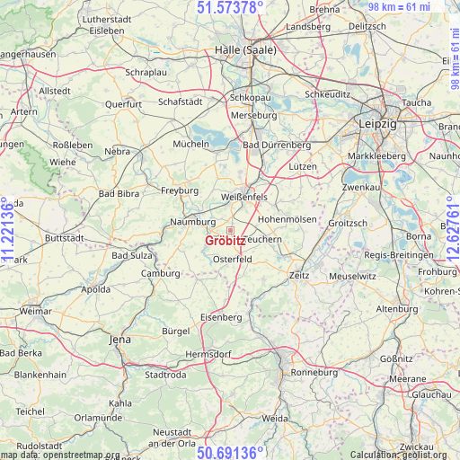
Gröbitz GPS coordinates[2]
51° 8' 4.848" North, 11° 55' 28.128" East
| Map corner | latitude | longitude |
|---|---|---|
| Upper-left | 51.57378°, | 11.22136° |
| Center: | 51.13468°, | 11.92448° |
| Lower-right: | 50.69136°, | 12.62761° |
| Map W x H: | 98.1×98.1 km | = 61×61mi |
| max Lat: | 55.01917° ⇑39.5% North |
| Gröbitz: | 51.13468° |
| min Lat: | ⇓60.5% South 47.40724° |
| min Long | Gröbitz | max Long |
| 5.92978° | 11.92448° | 14.98853° |
| W 80.7%⇐ | ⇒19.3% E |
Elevation
Elevation of Gröbitz is 195 m = 640 ft, and this is 54.1 m = 177 ft below average elevation for this country.
| Max E: |
1256 m = 4121 ft | 54.2% |
| Avg. | 249.1 m = 817 ft | |
| Gröbitz | 195 m = 640 ft | |
Min E: |
-5 m = -16 ft | 45.8% |
See also: Germany elevation on elevation.city.
Geographical zone
Gröbitz is located in North temperate zone (between Tropic of Cancer and the Arctic Circle). Distance of this North polar circle is 1715.5 km =1066 mi to North.| Distance of | km | miles | from Gröbitz |
|---|---|---|---|
| North Pole | 4321.4 | 2685.2 | to North |
| Arctic Circle | 1715.5 | 1066 | to North |
| Tropic Cancer | 3079.7 | 1913.6 | to South |
| Equator | 5685.6 | 3532.9 | to South |


Nearby cities:
15 places around Gröbitz: (largest is in red/bold)
• Görschen
3 km =1.9 mi,  212°
212°
• Krauschwitz
3.8 km =2.4 mi,  117°
117°
• Langendorf
5.6 km =3.5 mi,  27°
27°
• Leißling
5.4 km =3.4 mi,  348°
348°
• Meineweh
7.8 km =4.8 mi,  145°
145°
• Mertendorf
4.9 km =3 mi,  249°
249°
• Nessa
6 km =3.7 mi,  78°
78°
• Osterfeld
6.1 km =3.8 mi,  176°
176°
• Prittitz
1.7 km =1.1 mi,  13°
13°
• Schönburg
5.4 km =3.4 mi,  311°
311°
• Stößen
2.3 km =1.4 mi, 180°
• Teuchern
7.1 km =4.4 mi,  102°
102°
• Waldau
7.9 km =4.9 mi, 175°
• Weißenfels
8 km =5 mi,  22°
22°
• Wethau
4.7 km =2.9 mi,  273°
273°
Sources, notices
• [Note1] Compared only with cities in Germany existing in our database
• [Src1] Map data: © OpenStreetMap contributors (CC-BY-SA)
• [Src2] Other city data from geonames.org with taken over terms of usage.
• [Src3] Geographical zone / Annual Mean Temperature by Robert A. Rohde @ Wikipedia
