Weißenfels geodata
Weißenfels (Saxony-Anhalt) is a populated place; located in Germany in Europe/Berlin (GMT+2) time zone. With population of 29,792 people, there are 469 cities with bigger population in this country. Compared to other cities in Germany, 61.6% of cities are located further ↓South; 81.4% of cities are located further ←West and 68% of cities have higher elevation than Weißenfels. Note1


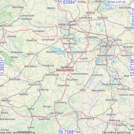
Weißenfels GPS coordinates[2]
51° 12' 5.328" North, 11° 58' 6.348" East
| Map corner | latitude | longitude |
|---|---|---|
| Upper-left | 51.63994°, | 11.26531° |
| Center: | 51.20148°, | 11.96843° |
| Lower-right: | 50.7588°, | 12.67156° |
| Map W x H: | 98×98 km | = 60.9×60.9mi |
| max Lat: | 55.01917° ⇑38.4% North |
| Weißenfels: | 51.20148° |
| min Lat: | ⇓61.6% South 47.40724° |
| min Long | Weißenfels | max Long |
| 5.92978° | 11.96843° | 14.98853° |
| W 81.4%⇐ | ⇒18.6% E |
Elevation
Elevation of Weißenfels is 102 m = 335 ft, and this is 147.1 m = 483 ft below average elevation for this country.
| Max E: |
1256 m = 4121 ft | 68% |
| Avg. | 249.1 m = 817 ft | |
| Weißenfels | 102 m = 335 ft | |
Min E: |
-5 m = -16 ft | 32% |
See also: Germany elevation on elevation.city.
Geographical zone
Weißenfels is located in North temperate zone (between Tropic of Cancer and the Arctic Circle). Distance of this North polar circle is 1708.1 km =1061.4 mi to North.| Distance of | km | miles | from Weißenfels |
|---|---|---|---|
| North Pole | 4314 | 2680.6 | to North |
| Arctic Circle | 1708.1 | 1061.4 | to North |
| Tropic Cancer | 3087.2 | 1918.3 | to South |
| Equator | 5693.1 | 3537.5 | to South |


Nearby cities:
15 places around Weißenfels: (largest is in red/bold)
• Burgwerben
2.6 km =1.6 mi,  24°
24°
• Dehlitz
4.9 km =3 mi,  49°
49°
• Goseck
7.1 km =4.4 mi,  268°
268°
• Granschütz
6.1 km =3.8 mi,  108°
108°
• Langendorf
2.5 km =1.6 mi,  191°
191°
• Leißling
4.6 km =2.9 mi,  242°
242°
• Markwerben
2.5 km =1.6 mi,  309°
309°
• Nessa
6.8 km =4.2 mi,  155°
155°
• Prittitz
6.3 km =3.9 mi,  204°
204°
• Reichardtswerben
5.3 km =3.3 mi,  348°
348°
• Schkortleben
5.8 km =3.6 mi,  36°
36°
• Storkau
4.2 km =2.6 mi, 313°
• Tagewerben
4.2 km =2.6 mi,  343°
343°
• Uichteritz
3.3 km =2.1 mi,  279°
279°
• Zorbau
3.9 km =2.4 mi, 106°
Sources, notices
• [Note1] Compared only with cities in Germany existing in our database
• [Src1] Map data: © OpenStreetMap contributors (CC-BY-SA)
• [Src2] Other city data from geonames.org with taken over terms of usage.
• [Src3] Geographical zone / Annual Mean Temperature by Robert A. Rohde @ Wikipedia
