Gribbohm geodata
Gribbohm (Schleswig-Holstein) is a seat of a fourth-order administrative division; located in Germany in Europe/Berlin (GMT+2) time zone. With population of 503 people, there are 9358 cities with bigger population in this country. Compared to other cities in Germany, 93% of cities are located further ↓South; 60.1% of cities are located further →East and 96.2% of cities have higher elevation than Gribbohm. Note1


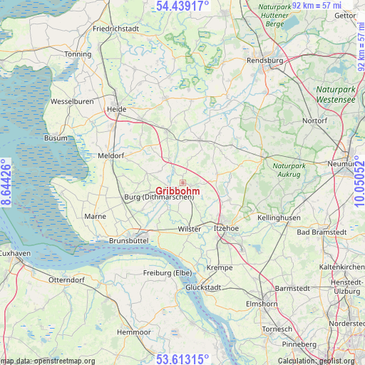
Gribbohm GPS coordinates[2]
54° 1' 41.556" North, 9° 20' 50.604" East
| Map corner | latitude | longitude |
|---|---|---|
| Upper-left | 54.43917°, | 8.64426° |
| Center: | 54.02821°, | 9.34739° |
| Lower-right: | 53.61315°, | 10.05052° |
| Map W x H: | 91.8×91.8 km | = 57×57mi |
| max Lat: | 55.01917° ⇑7% North |
| Gribbohm: | 54.02821° |
| min Lat: | ⇓93% South 47.40724° |
| min Long | Gribbohm | max Long |
| 5.92978° | 9.34739° | 14.98853° |
| W 39.9%⇐ | ⇒60.1% E |
Elevation
Elevation of Gribbohm is 6 m = 20 ft, and this is 243.1 m = 798 ft below average elevation for this country.
| Max E: |
1256 m = 4121 ft | 96.2% |
| Avg. | 249.1 m = 817 ft | |
| Gribbohm | 6 m = 20 ft | |
Min E: |
-5 m = -16 ft | 3.8% |
See also: Germany elevation on elevation.city.
Geographical zone
Gribbohm is located in North temperate zone (between Tropic of Cancer and the Arctic Circle). Distance of this North polar circle is 1393.8 km =866.1 mi to North.| Distance of | km | miles | from Gribbohm |
|---|---|---|---|
| North Pole | 3999.7 | 2485.3 | to North |
| Arctic Circle | 1393.8 | 866.1 | to North |
| Tropic Cancer | 3401.5 | 2113.6 | to South |
| Equator | 6007.4 | 3732.8 | to South |


Nearby cities:
15 places around Gribbohm: (largest is in red/bold)
• Agethorst
5.9 km =3.7 mi,  99°
99°
• Bendorf
6.6 km =4.1 mi,  20°
20°
• Besdorf
2.6 km =1.6 mi, 18°
• Bokelrehm
2.8 km =1.7 mi,  66°
66°
• Bokhorst
5.5 km =3.4 mi,  38°
38°
• Burg
6.7 km =4.2 mi,  239°
239°
• Eggstedt
5.8 km =3.6 mi,  294°
294°
• Hochdonn
4.7 km =2.9 mi,  267°
267°
• Holstenniendorf
1.5 km =0.9 mi,  1°
1°
• Mehlbek
6.3 km =3.9 mi,  114°
114°
• Nienbüttel
4.4 km =2.7 mi,  87°
87°
• Nutteln
5.2 km =3.2 mi,  150°
150°
• Vaale
3.9 km =2.4 mi,  143°
143°
• Vaalermoor
4.8 km =3 mi,  186°
186°
• Wacken
2 km =1.2 mi, 113°
Sources, notices
• [Note1] Compared only with cities in Germany existing in our database
• [Src1] Map data: © OpenStreetMap contributors (CC-BY-SA)
• [Src2] Other city data from geonames.org with taken over terms of usage.
• [Src3] Geographical zone / Annual Mean Temperature by Robert A. Rohde @ Wikipedia
