Hochdonn geodata
Hochdonn (Schleswig-Holstein) is a seat of a fourth-order administrative division; located in Germany in Europe/Berlin (GMT+2) time zone. With population of 1,233 people, there are 6486 cities with bigger population in this country. Compared to other cities in Germany, 93% of cities are located further ↓South; 61.1% of cities are located further →East and 98.6% of cities have higher elevation than Hochdonn. Note1
Administrative division(s):
- Level 1: Schleswig-Holstein
- Level 3: Kreis Dithmarschen
- Level 4: Hochdonn


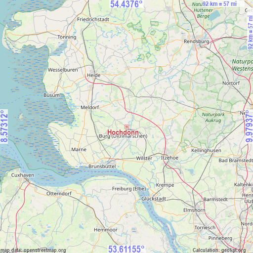
Hochdonn GPS coordinates[2]
54° 1' 35.868" North, 9° 16' 34.464" East
| Map corner | latitude | longitude |
|---|---|---|
| Upper-left | 54.4376°, | 8.57312° |
| Center: | 54.02663°, | 9.27624° |
| Lower-right: | 53.61155°, | 9.97937° |
| Map W x H: | 91.8×91.8 km | = 57×57mi |
| max Lat: | 55.01917° ⇑7% North |
| Hochdonn: | 54.02663° |
| min Lat: | ⇓93% South 47.40724° |
| min Long | Hochdonn | max Long |
| 5.92978° | 9.27624° | 14.98853° |
| W 38.9%⇐ | ⇒61.1% E |
Elevation
Elevation of Hochdonn is 1 m = 3 ft, and this is 248.1 m = 814 ft below average elevation for this country.
| Max E: |
1256 m = 4121 ft | 98.6% |
| Avg. | 249.1 m = 817 ft | |
| Hochdonn | 1 m = 3 ft | |
Min E: |
-5 m = -16 ft | 1.4% |
See also: Germany elevation on elevation.city.
Geographical zone
Hochdonn is located in North temperate zone (between Tropic of Cancer and the Arctic Circle). Distance of this North polar circle is 1394 km =866.2 mi to North.| Distance of | km | miles | from Hochdonn |
|---|---|---|---|
| North Pole | 3999.9 | 2485.4 | to North |
| Arctic Circle | 1394 | 866.2 | to North |
| Tropic Cancer | 3401.3 | 2113.5 | to South |
| Equator | 6007.2 | 3732.7 | to South |


Nearby cities:
15 places around Hochdonn: (largest is in red/bold)
• Aebtissinwisch
6.7 km =4.2 mi,  176°
176°
• Besdorf
6.1 km =3.8 mi,  64°
64°
• Brickeln
3 km =1.9 mi,  248°
248°
• Buchholz
5.5 km =3.4 mi,  218°
218°
• Burg
3.5 km =2.2 mi,  199°
199°
• Eggstedt
2.7 km =1.7 mi,  346°
346°
• Frestedt
6.1 km =3.8 mi,  276°
276°
• Gribbohm
4.7 km =2.9 mi,  87°
87°
• Großenrade
3.6 km =2.2 mi,  260°
260°
• Holstenniendorf
5 km =3.1 mi,  70°
70°
• Quickborn
4.7 km =2.9 mi, 247°
• Schafstedt
6.5 km =4 mi,  13°
13°
• Süderhastedt
5.1 km =3.2 mi,  299°
299°
• Vaalermoor
6.2 km =3.9 mi,  138°
138°
• Wacken
6.5 km =4 mi,  95°
95°
Sources, notices
• [Note1] Compared only with cities in Germany existing in our database
• [Src1] Map data: © OpenStreetMap contributors (CC-BY-SA)
• [Src2] Other city data from geonames.org with taken over terms of usage.
• [Src3] Geographical zone / Annual Mean Temperature by Robert A. Rohde @ Wikipedia
