Grafenau geodata
Grafenau (Bavaria) is a populated place; located in Germany in Europe/Berlin (GMT+2) time zone. With population of 8,870 people, there are 1812 cities with bigger population in this country. Compared to other cities in Germany, 84.6% of cities are located further ↑North; 95.1% of cities are located further ←West and 95.2% of cities have lower elevation than Grafenau. Note1
Administrative division(s):
- Level 1: Bavaria
- Level 2: Lower Bavaria
- Level 3: Landkreis Freyung-Grafenau
- Level 4: Grafenau


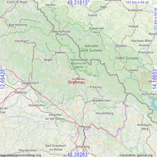
Grafenau GPS coordinates[2]
48° 51' 27.648" North, 13° 23' 50.64" East
| Map corner | latitude | longitude |
|---|---|---|
| Upper-left | 49.31815°, | 12.69428° |
| Center: | 48.85768°, | 13.3974° |
| Lower-right: | 48.39293°, | 14.10053° |
| Map W x H: | 102.9×102.9 km | = 63.9×63.9mi |
| max Lat: | 55.01917° ⇑84.6% North |
| Grafenau: | 48.85768° |
| min Lat: | ⇓15.4% South 47.40724° |
| min Long | Grafenau | max Long |
| 5.92978° | 13.3974° | 14.98853° |
| W 95.1%⇐ | ⇒4.9% E |
Elevation
Elevation of Grafenau is 604 m = 1982 ft, and this is 354.9 m = 1164 ft above average elevation for this country.
| Max E: |
1256 m = 4121 ft | 4.8% |
| Grafenau | 604 m 1982 ft | |
| Avg. | 249.1 m = 817 ft | |
Min E: |
-5 m = -16 ft | 95.2% |
See also: Germany elevation on elevation.city.
Geographical zone
Grafenau is located in North temperate zone (between Tropic of Cancer and the Arctic Circle). Distance of this North polar circle is 1968.7 km =1223.3 mi to North.| Distance of | km | miles | from Grafenau |
|---|---|---|---|
| North Pole | 4574.6 | 2842.5 | to North |
| Arctic Circle | 1968.7 | 1223.3 | to North |
| Tropic Cancer | 2826.5 | 1756.3 | to South |
| Equator | 5432.5 | 3375.6 | to South |


Nearby cities:
15 places around Grafenau: (largest is in red/bold)
• Eppenschlag
8 km =5 mi,  296°
296°
• Freyung
12.2 km =7.6 mi,  115°
115°
• Hohenau
6.7 km =4.2 mi,  97°
97°
• Innernzell
9 km =5.6 mi,  265°
265°
• Kirchdorf im Wald
11.3 km =7 mi, 301°
• Mauth
14.1 km =8.8 mi,  75°
75°
• Neuschönau
6.4 km =4 mi,  62°
62°
• Perlesreut
9 km =5.6 mi,  160°
160°
• Ringelai
7.3 km =4.5 mi,  132°
132°
• Saldenburg
9.9 km =6.2 mi,  197°
197°
• Schöfweg
12.5 km =7.8 mi,  260°
260°
• Spiegelau
6.9 km =4.3 mi,  338°
338°
• Thurmansbang
11.8 km =7.3 mi,  210°
210°
• Tittling
14.7 km =9.1 mi,  184°
184°
• Zenting
12.5 km =7.8 mi,  233°
233°
Sources, notices
• [Note1] Compared only with cities in Germany existing in our database
• [Src1] Map data: © OpenStreetMap contributors (CC-BY-SA)
• [Src2] Other city data from geonames.org with taken over terms of usage.
• [Src3] Geographical zone / Annual Mean Temperature by Robert A. Rohde @ Wikipedia
