Innernzell geodata
Innernzell (Bavaria) is a seat of a fourth-order administrative division; located in Germany in Europe/Berlin (GMT+2) time zone. With population of 1,722 people, there are 5472 cities with bigger population in this country. Compared to other cities in Germany, 84.6% of cities are located further ↑North; 94.2% of cities are located further ←West and 96.3% of cities have lower elevation than Innernzell. Note1
Administrative division(s):
- Level 1: Bavaria
- Level 2: Lower Bavaria
- Level 3: Landkreis Freyung-Grafenau
- Level 4: Innernzell


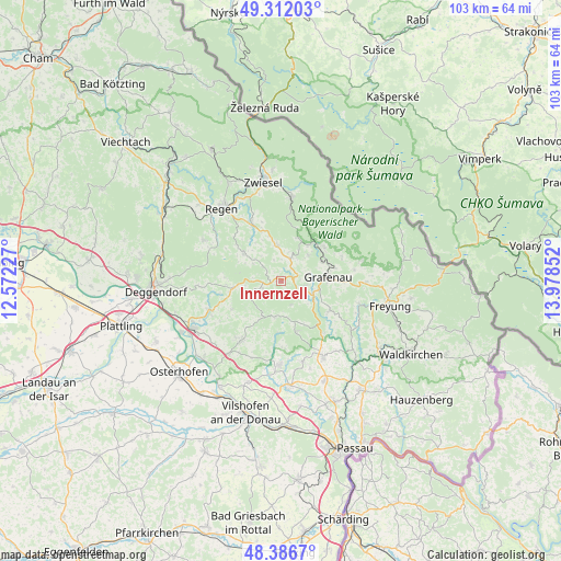
Innernzell GPS coordinates[2]
48° 51' 5.4" North, 13° 16' 31.404" East
| Map corner | latitude | longitude |
|---|---|---|
| Upper-left | 49.31203°, | 12.57227° |
| Center: | 48.8515°, | 13.27539° |
| Lower-right: | 48.3867°, | 13.97852° |
| Map W x H: | 102.9×102.9 km | = 63.9×63.9mi |
| max Lat: | 55.01917° ⇑84.6% North |
| Innernzell: | 48.8515° |
| min Lat: | ⇓15.4% South 47.40724° |
| min Long | Innernzell | max Long |
| 5.92978° | 13.27539° | 14.98853° |
| W 94.2%⇐ | ⇒5.8% E |
Elevation
Elevation of Innernzell is 637 m = 2090 ft, and this is 387.9 m = 1273 ft above average elevation for this country.
| Max E: |
1256 m = 4121 ft | 3.7% |
| Innernzell | 637 m 2090 ft | |
| Avg. | 249.1 m = 817 ft | |
Min E: |
-5 m = -16 ft | 96.3% |
See also: Germany elevation on elevation.city.
Geographical zone
Innernzell is located in North temperate zone (between Tropic of Cancer and the Arctic Circle). Distance of this North polar circle is 1969.4 km =1223.7 mi to North.| Distance of | km | miles | from Innernzell |
|---|---|---|---|
| North Pole | 4575.3 | 2843 | to North |
| Arctic Circle | 1969.4 | 1223.7 | to North |
| Tropic Cancer | 2825.9 | 1755.9 | to South |
| Equator | 5431.8 | 3375.2 | to South |


Nearby cities:
15 places around Innernzell: (largest is in red/bold)
• Auerbach
13.9 km =8.6 mi,  247°
247°
• Eppenschlag
4.6 km =2.9 mi,  23°
23°
• Grafenau
9 km =5.6 mi,  85°
85°
• Grattersdorf
10.4 km =6.5 mi,  239°
239°
• Hunding
7.3 km =4.5 mi,  261°
261°
• Kirchberg
8.7 km =5.4 mi,  308°
308°
• Kirchdorf im Wald
6.6 km =4.1 mi,  354°
354°
• Lalling
9.9 km =6.2 mi,  265°
265°
• Rinchnach
12.2 km =7.6 mi,  333°
333°
• Saldenburg
10.5 km =6.5 mi,  145°
145°
• Schöfweg
3.7 km =2.3 mi, 247°
• Schöllnach
13 km =8.1 mi,  213°
213°
• Spiegelau
9.5 km =5.9 mi,  41°
41°
• Thurmansbang
9.9 km =6.2 mi,  162°
162°
• Zenting
6.8 km =4.2 mi,  189°
189°
Sources, notices
• [Note1] Compared only with cities in Germany existing in our database
• [Src1] Map data: © OpenStreetMap contributors (CC-BY-SA)
• [Src2] Other city data from geonames.org with taken over terms of usage.
• [Src3] Geographical zone / Annual Mean Temperature by Robert A. Rohde @ Wikipedia
