Saldenburg geodata
Saldenburg (Bavaria) is a seat of a fourth-order administrative division; located in Germany in Europe/Berlin (GMT+2) time zone. With population of 2,040 people, there are 5007 cities with bigger population in this country. Compared to other cities in Germany, 85.6% of cities are located further ↑North; 94.8% of cities are located further ←West and 91.6% of cities have lower elevation than Saldenburg. Note1
Administrative division(s):
- Level 1: Bavaria
- Level 2: Lower Bavaria
- Level 3: Landkreis Freyung-Grafenau
- Level 4: Saldenburg


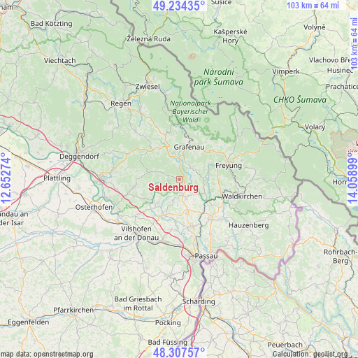
Saldenburg GPS coordinates[2]
48° 46' 23.16" North, 13° 21' 21.096" East
| Map corner | latitude | longitude |
|---|---|---|
| Upper-left | 49.23435°, | 12.65274° |
| Center: | 48.7731°, | 13.35586° |
| Lower-right: | 48.30757°, | 14.05899° |
| Map W x H: | 103×103 km | = 64×64mi |
| max Lat: | 55.01917° ⇑85.6% North |
| Saldenburg: | 48.7731° |
| min Lat: | ⇓14.4% South 47.40724° |
| min Long | Saldenburg | max Long |
| 5.92978° | 13.35586° | 14.98853° |
| W 94.8%⇐ | ⇒5.2% E |
Elevation
Elevation of Saldenburg is 536 m = 1759 ft, and this is 286.9 m = 941 ft above average elevation for this country.
| Max E: |
1256 m = 4121 ft | 8.4% |
| Saldenburg | 536 m 1759 ft | |
| Avg. | 249.1 m = 817 ft | |
Min E: |
-5 m = -16 ft | 91.6% |
See also: Germany elevation on elevation.city.
Geographical zone
Saldenburg is located in North temperate zone (between Tropic of Cancer and the Arctic Circle). Distance of this North polar circle is 1978.1 km =1229.1 mi to North.| Distance of | km | miles | from Saldenburg |
|---|---|---|---|
| North Pole | 4584 | 2848.4 | to North |
| Arctic Circle | 1978.1 | 1229.1 | to North |
| Tropic Cancer | 2817.1 | 1750.5 | to South |
| Equator | 5423.1 | 3369.8 | to South |


Nearby cities:
15 places around Saldenburg: (largest is in red/bold)
• Aicha vorm Wald
11.7 km =7.3 mi,  202°
202°
• Außernzell
12.5 km =7.8 mi,  244°
244°
• Fürsteneck
10.3 km =6.4 mi,  127°
127°
• Fürstenstein
6.5 km =4 mi,  194°
194°
• Grafenau
9.9 km =6.2 mi,  17°
17°
• Innernzell
10.5 km =6.5 mi,  325°
325°
• Neukirchen vorm Wald
10.2 km =6.3 mi,  168°
168°
• Perlesreut
6.1 km =3.8 mi,  80°
80°
• Ringelai
9.6 km =6 mi,  62°
62°
• Röhrnbach
12.8 km =8 mi,  107°
107°
• Schöfweg
11.8 km =7.3 mi,  308°
308°
• Thurmansbang
3.1 km =1.9 mi,  255°
255°
• Tittling
5.6 km =3.5 mi,  159°
159°
• Witzmannsberg
7.7 km =4.8 mi,  144°
144°
• Zenting
7.3 km =4.5 mi,  286°
286°
Sources, notices
• [Note1] Compared only with cities in Germany existing in our database
• [Src1] Map data: © OpenStreetMap contributors (CC-BY-SA)
• [Src2] Other city data from geonames.org with taken over terms of usage.
• [Src3] Geographical zone / Annual Mean Temperature by Robert A. Rohde @ Wikipedia
