Eppenschlag geodata
Eppenschlag (Bavaria) is a seat of a fourth-order administrative division; located in Germany in Europe/Berlin (GMT+2) time zone. With population of 952 people, there are 7340 cities with bigger population in this country. Compared to other cities in Germany, 84.2% of cities are located further ↑North; 94.4% of cities are located further ←West and 95.5% of cities have lower elevation than Eppenschlag. Note1
Administrative division(s):
- Level 1: Bavaria
- Level 2: Lower Bavaria
- Level 3: Landkreis Freyung-Grafenau
- Level 4: Eppenschlag


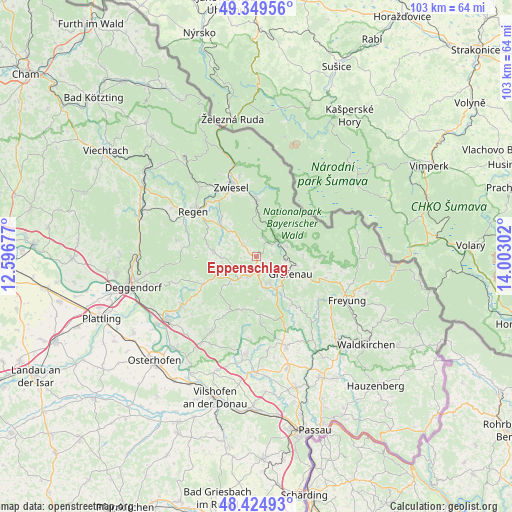
Eppenschlag GPS coordinates[2]
48° 53' 21.768" North, 13° 17' 59.604" East
| Map corner | latitude | longitude |
|---|---|---|
| Upper-left | 49.34956°, | 12.59677° |
| Center: | 48.88938°, | 13.29989° |
| Lower-right: | 48.42493°, | 14.00302° |
| Map W x H: | 102.8×102.8 km | = 63.9×63.9mi |
| max Lat: | 55.01917° ⇑84.2% North |
| Eppenschlag: | 48.88938° |
| min Lat: | ⇓15.8% South 47.40724° |
| min Long | Eppenschlag | max Long |
| 5.92978° | 13.29989° | 14.98853° |
| W 94.4%⇐ | ⇒5.6% E |
Elevation
Elevation of Eppenschlag is 610 m = 2001 ft, and this is 360.9 m = 1184 ft above average elevation for this country.
| Max E: |
1256 m = 4121 ft | 4.5% |
| Eppenschlag | 610 m 2001 ft | |
| Avg. | 249.1 m = 817 ft | |
Min E: |
-5 m = -16 ft | 95.5% |
See also: Germany elevation on elevation.city.
Geographical zone
Eppenschlag is located in North temperate zone (between Tropic of Cancer and the Arctic Circle). Distance of this North polar circle is 1965.2 km =1221.1 mi to North.| Distance of | km | miles | from Eppenschlag |
|---|---|---|---|
| North Pole | 4571.1 | 2840.3 | to North |
| Arctic Circle | 1965.2 | 1221.1 | to North |
| Tropic Cancer | 2830.1 | 1758.5 | to South |
| Equator | 5436 | 3377.8 | to South |


Nearby cities:
15 places around Eppenschlag: (largest is in red/bold)
• Frauenau
11.1 km =6.9 mi,  0°
0°
• Grafenau
8 km =5 mi,  116°
116°
• Grattersdorf
14.3 km =8.9 mi,  228°
228°
• Hunding
10.4 km =6.5 mi,  239°
239°
• Innernzell
4.6 km =2.9 mi,  203°
203°
• Kirchberg
8.7 km =5.4 mi,  277°
277°
• Kirchdorf im Wald
3.4 km =2.1 mi,  313°
313°
• Lalling
12.7 km =7.9 mi,  247°
247°
• Neuschönau
12.9 km =8 mi,  92°
92°
• Rinchnach
9.8 km =6.1 mi, 312°
• Saldenburg
13.6 km =8.5 mi,  162°
162°
• Schöfweg
7.7 km =4.8 mi,  222°
222°
• Spiegelau
5.4 km =3.4 mi,  57°
57°
• Thurmansbang
13.7 km =8.5 mi,  175°
175°
• Zenting
11.3 km =7 mi, 195°
Sources, notices
• [Note1] Compared only with cities in Germany existing in our database
• [Src1] Map data: © OpenStreetMap contributors (CC-BY-SA)
• [Src2] Other city data from geonames.org with taken over terms of usage.
• [Src3] Geographical zone / Annual Mean Temperature by Robert A. Rohde @ Wikipedia
