Gottmadingen geodata
Gottmadingen (Baden-Württemberg) is a seat of a fourth-order administrative division; located in Germany in Europe/Berlin (GMT+2) time zone. With population of 10,452 people, there are 1576 cities with bigger population in this country. Compared to other cities in Germany, 98.4% of cities are located further ↑North; 68.2% of cities are located further →East and 79.1% of cities have lower elevation than Gottmadingen. Note1
Administrative division(s):
- Level 1: Baden-Württemberg
- Level 2: Freiburg Region
- Level 3: Landkreis Konstanz
- Level 4: Gottmadingen


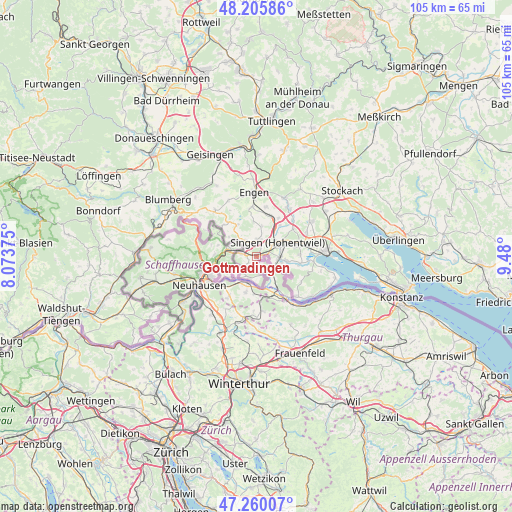
Gottmadingen GPS coordinates[2]
47° 44' 6.396" North, 8° 46' 36.732" East
| Map corner | latitude | longitude |
|---|---|---|
| Upper-left | 48.20586°, | 8.07375° |
| Center: | 47.73511°, | 8.77687° |
| Lower-right: | 47.26007°, | 9.48° |
| Map W x H: | 105.2×105.2 km | = 65.4×65.4mi |
| max Lat: | 55.01917° ⇑98.4% North |
| Gottmadingen: | 47.73511° |
| min Lat: | ⇓1.6% South 47.40724° |
| min Long | Gottmadingen | max Long |
| 5.92978° | 8.77687° | 14.98853° |
| W 31.8%⇐ | ⇒68.2% E |
Elevation
Elevation of Gottmadingen is 428 m = 1404 ft, and this is 178.9 m = 587 ft above average elevation for this country.
| Max E: |
1256 m = 4121 ft | 20.9% |
| Gottmadingen | 428 m 1404 ft | |
| Avg. | 249.1 m = 817 ft | |
Min E: |
-5 m = -16 ft | 79.1% |
See also: Germany elevation on elevation.city.
Geographical zone
Gottmadingen is located in North temperate zone (between Tropic of Cancer and the Arctic Circle). Distance of this North polar circle is 2093.5 km =1300.8 mi to North.| Distance of | km | miles | from Gottmadingen |
|---|---|---|---|
| North Pole | 4699.4 | 2920.1 | to North |
| Arctic Circle | 2093.5 | 1300.8 | to North |
| Tropic Cancer | 2701.7 | 1678.8 | to South |
| Equator | 5307.6 | 3298 | to South |


Nearby cities:
15 places around Gottmadingen: (largest is in red/bold)
• Aach
13.2 km =8.2 mi,  25°
25°
• Büsingen
7.9 km =4.9 mi,  237°
237°
• Engen
13.4 km =8.3 mi,  358°
358°
• Gailingen
4.5 km =2.8 mi,  200°
200°
• Hilzingen
3.5 km =2.2 mi,  7°
7°
• Moos
11.9 km =7.4 mi,  95°
95°
• Mühlhausen-Ehingen
8.8 km =5.5 mi,  17°
17°
• Neuhausen
11.4 km =7.1 mi, 359°
• Radolfzell
14.5 km =9 mi,  87°
87°
• Rielasingen-Worblingen
4.7 km =2.9 mi, 90°
• Singen
5.5 km =3.4 mi,  60°
60°
• Steißlingen
13.7 km =8.5 mi, 58°
• Tengen
12.9 km =8 mi,  317°
317°
• Volkertshausen
11.3 km =7 mi,  36°
36°
• Öhningen
11.6 km =7.2 mi,  134°
134°
Sources, notices
• [Note1] Compared only with cities in Germany existing in our database
• [Src1] Map data: © OpenStreetMap contributors (CC-BY-SA)
• [Src2] Other city data from geonames.org with taken over terms of usage.
• [Src3] Geographical zone / Annual Mean Temperature by Robert A. Rohde @ Wikipedia
