Büsingen geodata
Büsingen (Baden-Württemberg) is a populated place; located in Germany in Europe/Busingen (GMT+2) time zone. With population of 1,473 people, there are 5930 cities with bigger population in this country. Compared to other cities in Germany, 98.8% of cities are located further ↑North; 69.2% of cities are located further →East and 74.8% of cities have lower elevation than Büsingen. Note1
Administrative division(s):
- Level 1: Baden-Württemberg
- Level 2: Freiburg Region
- Level 3: Landkreis Konstanz
- Level 4: Büsingen am Hochrhein


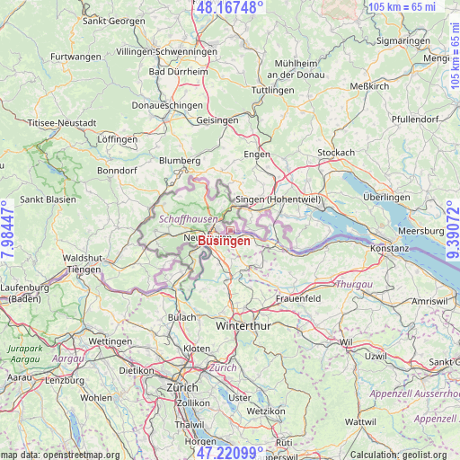
Büsingen GPS coordinates[2]
47° 41' 46.968" North, 8° 41' 15.324" East
| Map corner | latitude | longitude |
|---|---|---|
| Upper-left | 48.16748°, | 7.98447° |
| Center: | 47.69638°, | 8.68759° |
| Lower-right: | 47.22099°, | 9.39072° |
| Map W x H: | 105.2×105.2 km | = 65.4×65.4mi |
| max Lat: | 55.01917° ⇑98.8% North |
| Büsingen: | 47.69638° |
| min Lat: | ⇓1.2% South 47.40724° |
| min Long | Büsingen | max Long |
| 5.92978° | 8.68759° | 14.98853° |
| W 30.8%⇐ | ⇒69.2% E |
Elevation
Elevation of Büsingen is 396 m = 1299 ft, and this is 146.9 m = 482 ft above average elevation for this country.
| Max E: |
1256 m = 4121 ft | 25.2% |
| Büsingen | 396 m 1299 ft | |
| Avg. | 249.1 m = 817 ft | |
Min E: |
-5 m = -16 ft | 74.8% |
See also: Germany elevation on elevation.city.
Geographical zone
Büsingen is located in North temperate zone (between Tropic of Cancer and the Arctic Circle). Distance of this North polar circle is 2097.8 km =1303.5 mi to North.| Distance of | km | miles | from Büsingen |
|---|---|---|---|
| North Pole | 4703.7 | 2922.7 | to North |
| Arctic Circle | 2097.8 | 1303.5 | to North |
| Tropic Cancer | 2697.4 | 1676.1 | to South |
| Equator | 5303.3 | 3295.3 | to South |


Nearby cities:
15 places around Büsingen: (largest is in red/bold)
• Dettighofen
17.2 km =10.7 mi,  241°
241°
• Engen
18.8 km =11.7 mi,  19°
19°
• Gailingen
5.1 km =3.2 mi,  89°
89°
• Gottmadingen
7.9 km =4.9 mi,  57°
57°
• Hilzingen
10.6 km =6.6 mi,  42°
42°
• Jestetten
10.4 km =6.5 mi, 240°
• Lottstetten
11.5 km =7.1 mi,  232°
232°
• Moos
18.8 km =11.7 mi,  80°
80°
• Mühlhausen-Ehingen
15.8 km =9.8 mi, 36°
• Neuhausen
17 km =10.6 mi, 22°
• Rielasingen-Worblingen
12.2 km =7.6 mi,  69°
69°
• Singen
13.4 km =8.3 mi, 58°
• Stühlingen
18.7 km =11.6 mi,  287°
287°
• Tengen
14 km =8.7 mi,  351°
351°
• Öhningen
15.4 km =9.6 mi,  104°
104°
Sources, notices
• [Note1] Compared only with cities in Germany existing in our database
• [Src1] Map data: © OpenStreetMap contributors (CC-BY-SA)
• [Src2] Other city data from geonames.org with taken over terms of usage.
• [Src3] Geographical zone / Annual Mean Temperature by Robert A. Rohde @ Wikipedia
