Tengen geodata
Tengen (Baden-Württemberg) is a populated place; located in Germany in Europe/Berlin (GMT+2) time zone. With population of 4,670 people, there are 2951 cities with bigger population in this country. Compared to other cities in Germany, 97.4% of cities are located further ↑North; 69.5% of cities are located further →East and 96.4% of cities have lower elevation than Tengen. Note1
Administrative division(s):
- Level 1: Baden-Württemberg
- Level 2: Freiburg Region
- Level 3: Landkreis Konstanz
- Level 4: Tengen


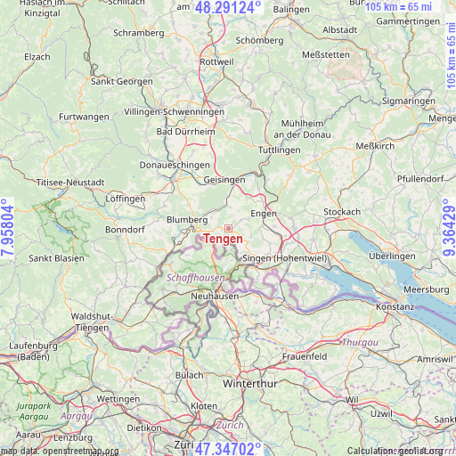
Tengen GPS coordinates[2]
47° 49' 16.608" North, 8° 39' 40.212" East
| Map corner | latitude | longitude |
|---|---|---|
| Upper-left | 48.29124°, | 7.95804° |
| Center: | 47.82128°, | 8.66117° |
| Lower-right: | 47.34702°, | 9.36429° |
| Map W x H: | 105×105 km | = 65.2×65.2mi |
| max Lat: | 55.01917° ⇑97.4% North |
| Tengen: | 47.82128° |
| min Lat: | ⇓2.6% South 47.40724° |
| min Long | Tengen | max Long |
| 5.92978° | 8.66117° | 14.98853° |
| W 30.5%⇐ | ⇒69.5% E |
Elevation
Elevation of Tengen is 639 m = 2096 ft, and this is 389.9 m = 1279 ft above average elevation for this country.
| Max E: |
1256 m = 4121 ft | 3.6% |
| Tengen | 639 m 2096 ft | |
| Avg. | 249.1 m = 817 ft | |
Min E: |
-5 m = -16 ft | 96.4% |
See also: Germany elevation on elevation.city.
Geographical zone
Tengen is located in North temperate zone (between Tropic of Cancer and the Arctic Circle). Distance of this North polar circle is 2083.9 km =1294.9 mi to North.| Distance of | km | miles | from Tengen |
|---|---|---|---|
| North Pole | 4689.8 | 2914.1 | to North |
| Arctic Circle | 2083.9 | 1294.9 | to North |
| Tropic Cancer | 2711.3 | 1684.7 | to South |
| Equator | 5317.2 | 3304 | to South |


Nearby cities:
15 places around Tengen: (largest is in red/bold)
• Aach
14.6 km =9.1 mi,  80°
80°
• Blumberg
9.8 km =6.1 mi,  282°
282°
• Büsingen
14 km =8.7 mi,  171°
171°
• Engen
9.2 km =5.7 mi,  65°
65°
• Gailingen
15.5 km =9.6 mi,  152°
152°
• Geisingen
11.6 km =7.2 mi,  355°
355°
• Gottmadingen
12.9 km =8 mi,  137°
137°
• Hausen
10.6 km =6.6 mi,  5°
5°
• Hilzingen
11 km =6.8 mi,  123°
123°
• Immendingen
13.6 km =8.5 mi,  23°
23°
• Mühlhausen-Ehingen
11.3 km =7 mi,  95°
95°
• Neuhausen
8.6 km =5.3 mi, 77°
• Rielasingen-Worblingen
16.5 km =10.3 mi,  125°
125°
• Singen
15 km =9.3 mi, 117°
• Volkertshausen
15.4 km =9.6 mi,  91°
91°
Sources, notices
• [Note1] Compared only with cities in Germany existing in our database
• [Src1] Map data: © OpenStreetMap contributors (CC-BY-SA)
• [Src2] Other city data from geonames.org with taken over terms of usage.
• [Src3] Geographical zone / Annual Mean Temperature by Robert A. Rohde @ Wikipedia
