Göttingen geodata
Göttingen (Lower Saxony) is a seat of a third-order administrative division; located in Germany in Europe/Berlin (GMT+2) time zone. With population of 122,149 people, there are 71 cities with bigger population in this country. Compared to other cities in Germany, 66.8% of cities are located further ↓South; 51.1% of cities are located further →East and 60% of cities have higher elevation than Göttingen. Note1


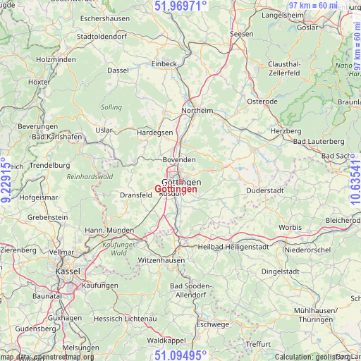
Göttingen GPS coordinates[2]
51° 32' 3.948" North, 9° 55' 56.208" East
| Map corner | latitude | longitude |
|---|---|---|
| Upper-left | 51.96971°, | 9.22915° |
| Center: | 51.53443°, | 9.93228° |
| Lower-right: | 51.09495°, | 10.63541° |
| Map W x H: | 97.3×97.3 km | = 60.5×60.5mi |
| max Lat: | 55.01917° ⇑33.2% North |
| Göttingen: | 51.53443° |
| min Lat: | ⇓66.8% South 47.40724° |
| min Long | Göttingen | max Long |
| 5.92978° | 9.93228° | 14.98853° |
| W 48.9%⇐ | ⇒51.1% E |
Elevation
Elevation of Göttingen is 153 m = 502 ft, and this is 96.1 m = 315 ft below average elevation for this country.
| Max E: |
1256 m = 4121 ft | 60% |
| Avg. | 249.1 m = 817 ft | |
| Göttingen | 153 m = 502 ft | |
Min E: |
-5 m = -16 ft | 40% |
See also: Göttingen elevation on elevation.city.
Geographical zone
Göttingen is located in North temperate zone (between Tropic of Cancer and the Arctic Circle). Distance of this North polar circle is 1671.1 km =1038.4 mi to North.| Distance of | km | miles | from Göttingen |
|---|---|---|---|
| North Pole | 4277 | 2657.6 | to North |
| Arctic Circle | 1671.1 | 1038.4 | to North |
| Tropic Cancer | 3124.2 | 1941.3 | to South |
| Equator | 5730.1 | 3560.5 | to South |


Nearby cities:
15 places around Göttingen: (largest is in red/bold)
• Adelebsen
13.4 km =8.3 mi,  293°
293°
• Bovenden
6 km =3.7 mi,  353°
353°
• Dransfeld
12.4 km =7.7 mi,  251°
251°
• Ebergötzen
12.7 km =7.9 mi,  71°
71°
• Freienhagen
15.4 km =9.6 mi,  148°
148°
• Friedland
12.9 km =8 mi,  184°
184°
• Gemeinde Friedland
13.1 km =8.1 mi, 179°
• Hardegsen
14.9 km =9.3 mi,  331°
331°
• Jühnde
11.9 km =7.4 mi,  230°
230°
• Krebeck
13.9 km =8.6 mi, 66°
• Landolfshausen
11.6 km =7.2 mi,  90°
90°
• Nörten-Hardenberg
10.5 km =6.5 mi,  1°
1°
• Rohrberg
14.3 km =8.9 mi,  155°
155°
• Rosdorf
4.4 km =2.7 mi,  210°
210°
• Waake
9 km =5.6 mi, 74°
Sources, notices
• [Note1] Compared only with cities in Germany existing in our database
• [Src1] Map data: © OpenStreetMap contributors (CC-BY-SA)
• [Src2] Other city data from geonames.org with taken over terms of usage.
• [Src3] Geographical zone / Annual Mean Temperature by Robert A. Rohde @ Wikipedia
