Hardegsen geodata
Hardegsen (Lower Saxony) is a populated place; located in Germany in Europe/Berlin (GMT+2) time zone. With population of 8,621 people, there are 1854 cities with bigger population in this country. Compared to other cities in Germany, 68.3% of cities are located further ↓South; 52.4% of cities are located further →East and 55.7% of cities have higher elevation than Hardegsen. Note1


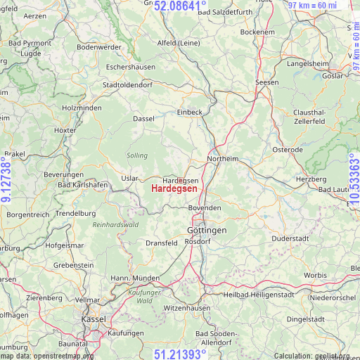
Hardegsen GPS coordinates[2]
51° 39' 8.172" North, 9° 49' 49.8" East
| Map corner | latitude | longitude |
|---|---|---|
| Upper-left | 52.08641°, | 9.12738° |
| Center: | 51.65227°, | 9.8305° |
| Lower-right: | 51.21393°, | 10.53363° |
| Map W x H: | 97×97 km | = 60.3×60.3mi |
| max Lat: | 55.01917° ⇑31.7% North |
| Hardegsen: | 51.65227° |
| min Lat: | ⇓68.3% South 47.40724° |
| min Long | Hardegsen | max Long |
| 5.92978° | 9.8305° | 14.98853° |
| W 47.6%⇐ | ⇒52.4% E |
Elevation
Elevation of Hardegsen is 184 m = 604 ft, and this is 65.1 m = 214 ft below average elevation for this country.
| Max E: |
1256 m = 4121 ft | 55.7% |
| Avg. | 249.1 m = 817 ft | |
| Hardegsen | 184 m = 604 ft | |
Min E: |
-5 m = -16 ft | 44.3% |
See also: Germany elevation on elevation.city.
Geographical zone
Hardegsen is located in North temperate zone (between Tropic of Cancer and the Arctic Circle). Distance of this North polar circle is 1658 km =1030.2 mi to North.| Distance of | km | miles | from Hardegsen |
|---|---|---|---|
| North Pole | 4263.9 | 2649.5 | to North |
| Arctic Circle | 1658 | 1030.2 | to North |
| Tropic Cancer | 3137.3 | 1949.4 | to South |
| Equator | 5743.2 | 3568.7 | to South |


Nearby cities:
15 places around Hardegsen: (largest is in red/bold)
• Adelebsen
9.3 km =5.8 mi,  214°
214°
• Bodenfelde
19 km =11.8 mi,  266°
266°
• Bovenden
9.5 km =5.9 mi,  138°
138°
• Dassel
19.3 km =12 mi,  329°
329°
• Dransfeld
17.7 km =11 mi,  195°
195°
• Einbeck
18.9 km =11.7 mi,  8°
8°
• Göttingen
14.9 km =9.3 mi,  151°
151°
• Hillerse
9 km =5.6 mi,  65°
65°
• Katlenburg-Lindau
18.9 km =11.7 mi,  79°
79°
• Moringen
5.9 km =3.7 mi,  28°
28°
• Northeim
13.2 km =8.2 mi,  62°
62°
• Nörten-Hardenberg
7.7 km =4.8 mi,  109°
109°
• Rosdorf
17.6 km =10.9 mi,  164°
164°
• Uslar
13.5 km =8.4 mi, 272°
• Waake
18.9 km =11.7 mi,  124°
124°
Sources, notices
• [Note1] Compared only with cities in Germany existing in our database
• [Src1] Map data: © OpenStreetMap contributors (CC-BY-SA)
• [Src2] Other city data from geonames.org with taken over terms of usage.
• [Src3] Geographical zone / Annual Mean Temperature by Robert A. Rohde @ Wikipedia
