Bovenden geodata
Bovenden (Lower Saxony) is a populated place; located in Germany in Europe/Berlin (GMT+2) time zone. With population of 13,964 people, there are 1139 cities with bigger population in this country. Compared to other cities in Germany, 67.5% of cities are located further ↓South; 51.1% of cities are located further →East and 61.5% of cities have higher elevation than Bovenden. Note1
Administrative division(s):
- Level 1: Lower Saxony
- Level 3: Landkreis Göttingen
- Level 4: Bovenden, Flecken


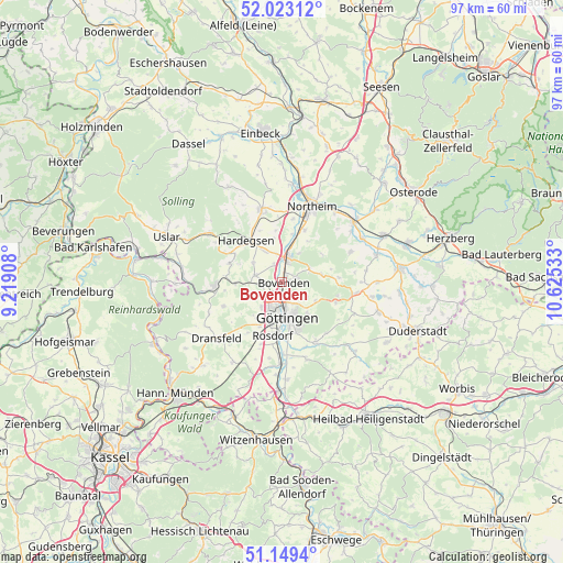
Bovenden GPS coordinates[2]
51° 35' 18.096" North, 9° 55' 19.92" East
| Map corner | latitude | longitude |
|---|---|---|
| Upper-left | 52.02312°, | 9.21908° |
| Center: | 51.58836°, | 9.9222° |
| Lower-right: | 51.1494°, | 10.62533° |
| Map W x H: | 97.1×97.1 km | = 60.3×60.3mi |
| max Lat: | 55.01917° ⇑32.5% North |
| Bovenden: | 51.58836° |
| min Lat: | ⇓67.5% South 47.40724° |
| min Long | Bovenden | max Long |
| 5.92978° | 9.9222° | 14.98853° |
| W 48.9%⇐ | ⇒51.1% E |
Elevation
Elevation of Bovenden is 142 m = 466 ft, and this is 107.1 m = 351 ft below average elevation for this country.
| Max E: |
1256 m = 4121 ft | 61.5% |
| Avg. | 249.1 m = 817 ft | |
| Bovenden | 142 m = 466 ft | |
Min E: |
-5 m = -16 ft | 38.5% |
See also: Germany elevation on elevation.city.
Geographical zone
Bovenden is located in North temperate zone (between Tropic of Cancer and the Arctic Circle). Distance of this North polar circle is 1665.1 km =1034.6 mi to North.| Distance of | km | miles | from Bovenden |
|---|---|---|---|
| North Pole | 4271 | 2653.9 | to North |
| Arctic Circle | 1665.1 | 1034.6 | to North |
| Tropic Cancer | 3130.2 | 1945 | to South |
| Equator | 5736.1 | 3564.2 | to South |


Nearby cities:
15 places around Bovenden: (largest is in red/bold)
• Adelebsen
11.6 km =7.2 mi,  266°
266°
• Bodensee
14.7 km =9.1 mi,  82°
82°
• Dransfeld
14.9 km =9.3 mi,  228°
228°
• Ebergötzen
12.9 km =8 mi,  98°
98°
• Göttingen
6 km =3.7 mi,  173°
173°
• Hardegsen
9.5 km =5.9 mi,  318°
318°
• Hillerse
11 km =6.8 mi,  9°
9°
• Krebeck
13.4 km =8.3 mi,  92°
92°
• Landolfshausen
13.7 km =8.5 mi,  116°
116°
• Moringen
12.8 km =8 mi,  344°
344°
• Northeim
14.2 km =8.8 mi,  22°
22°
• Nörten-Hardenberg
4.6 km =2.9 mi, 11°
• Rosdorf
9.9 km =6.2 mi,  188°
188°
• Seeburg
15.9 km =9.9 mi, 98°
• Waake
10 km =6.2 mi,  110°
110°
Sources, notices
• [Note1] Compared only with cities in Germany existing in our database
• [Src1] Map data: © OpenStreetMap contributors (CC-BY-SA)
• [Src2] Other city data from geonames.org with taken over terms of usage.
• [Src3] Geographical zone / Annual Mean Temperature by Robert A. Rohde @ Wikipedia
