Görzig geodata
Görzig (Saxony-Anhalt) is a populated place; located in Germany in Europe/Berlin (GMT+2) time zone. With population of 1,295 people, there are 6320 cities with bigger population in this country. Compared to other cities in Germany, 68.5% of cities are located further ↓South; 81.7% of cities are located further ←West and 71.5% of cities have higher elevation than Görzig. Note1
Administrative division(s):
- Level 1: Saxony-Anhalt
- Level 3: Anhalt-Bitterfeld
- Level 4: Südliches Anhalt


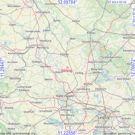
Görzig GPS coordinates[2]
51° 39' 49.716" North, 11° 59' 51.324" East
| Map corner | latitude | longitude |
|---|---|---|
| Upper-left | 52.09784°, | 11.29447° |
| Center: | 51.66381°, | 11.99759° |
| Lower-right: | 51.22558°, | 12.70072° |
| Map W x H: | 97×97 km | = 60.3×60.3mi |
| max Lat: | 55.01917° ⇑31.5% North |
| Görzig: | 51.66381° |
| min Lat: | ⇓68.5% South 47.40724° |
| min Long | Görzig | max Long |
| 5.92978° | 11.99759° | 14.98853° |
| W 81.7%⇐ | ⇒18.3% E |
Elevation
Elevation of Görzig is 81 m = 266 ft, and this is 168.1 m = 552 ft below average elevation for this country.
| Max E: |
1256 m = 4121 ft | 71.5% |
| Avg. | 249.1 m = 817 ft | |
| Görzig | 81 m = 266 ft | |
Min E: |
-5 m = -16 ft | 28.5% |
See also: Germany elevation on elevation.city.
Geographical zone
Görzig is located in North temperate zone (between Tropic of Cancer and the Arctic Circle). Distance of this North polar circle is 1656.7 km =1029.4 mi to North.| Distance of | km | miles | from Görzig |
|---|---|---|---|
| North Pole | 4262.6 | 2648.7 | to North |
| Arctic Circle | 1656.7 | 1029.4 | to North |
| Tropic Cancer | 3138.6 | 1950.2 | to South |
| Equator | 5744.5 | 3569.5 | to South |


Nearby cities:
15 places around Görzig: (largest is in red/bold)
• Edderitz
5.7 km =3.5 mi,  313°
313°
• Großbadegast
7.8 km =4.8 mi,  14°
14°
• Gröbzig
8.7 km =5.4 mi,  283°
283°
• Krosigk
7.5 km =4.7 mi,  215°
215°
• Köthen
10 km =6.2 mi,  349°
349°
• Löbejün
7.4 km =4.6 mi,  244°
244°
• Petersberg
8.1 km =5 mi,  202°
202°
• Plötz
4.4 km =2.7 mi,  229°
229°
• Prosigk
5.6 km =3.5 mi,  44°
44°
• Radegast
6.8 km =4.2 mi,  96°
96°
• Schortewitz
2.3 km =1.4 mi,  125°
125°
• Schrenz
9.9 km =6.2 mi,  148°
148°
• Stumsdorf
7 km =4.3 mi,  139°
139°
• Weißandt-Gölzau
5.3 km =3.3 mi,  81°
81°
• Zörbig
9.1 km =5.7 mi,  115°
115°
Sources, notices
• [Note1] Compared only with cities in Germany existing in our database
• [Src1] Map data: © OpenStreetMap contributors (CC-BY-SA)
• [Src2] Other city data from geonames.org with taken over terms of usage.
• [Src3] Geographical zone / Annual Mean Temperature by Robert A. Rohde @ Wikipedia
