Radegast geodata
Radegast (Saxony-Anhalt) is a populated place; located in Germany in Europe/Berlin (GMT+2) time zone. With population of 1,308 people, there are 6289 cities with bigger population in this country. Compared to other cities in Germany, 68.4% of cities are located further ↓South; 83.2% of cities are located further ←West and 71.2% of cities have higher elevation than Radegast. Note1
Administrative division(s):
- Level 1: Saxony-Anhalt
- Level 3: Anhalt-Bitterfeld
- Level 4: Südliches Anhalt


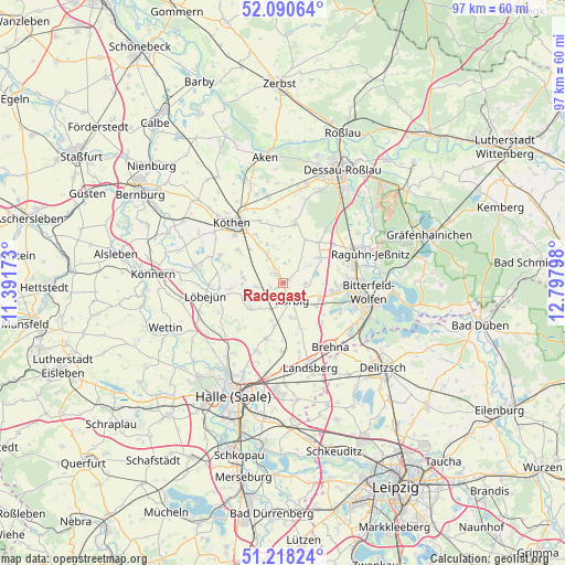
Radegast GPS coordinates[2]
51° 39' 23.544" North, 12° 5' 41.46" East
| Map corner | latitude | longitude |
|---|---|---|
| Upper-left | 52.09064°, | 11.39173° |
| Center: | 51.65654°, | 12.09485° |
| Lower-right: | 51.21824°, | 12.79798° |
| Map W x H: | 97×97 km | = 60.3×60.3mi |
| max Lat: | 55.01917° ⇑31.6% North |
| Radegast: | 51.65654° |
| min Lat: | ⇓68.4% South 47.40724° |
| min Long | Radegast | max Long |
| 5.92978° | 12.09485° | 14.98853° |
| W 83.2%⇐ | ⇒16.8% E |
Elevation
Elevation of Radegast is 83 m = 272 ft, and this is 166.1 m = 545 ft below average elevation for this country.
| Max E: |
1256 m = 4121 ft | 71.2% |
| Avg. | 249.1 m = 817 ft | |
| Radegast | 83 m = 272 ft | |
Min E: |
-5 m = -16 ft | 28.8% |
See also: Germany elevation on elevation.city.
Geographical zone
Radegast is located in North temperate zone (between Tropic of Cancer and the Arctic Circle). Distance of this North polar circle is 1657.5 km =1029.9 mi to North.| Distance of | km | miles | from Radegast |
|---|---|---|---|
| North Pole | 4263.4 | 2649.2 | to North |
| Arctic Circle | 1657.5 | 1029.9 | to North |
| Tropic Cancer | 3137.7 | 1949.7 | to South |
| Equator | 5743.7 | 3569 | to South |


Nearby cities:
15 places around Radegast: (largest is in red/bold)
• Glebitzsch
9.4 km =5.8 mi,  135°
135°
• Großzöberitz
7.1 km =4.4 mi,  125°
125°
• Görzig
6.8 km =4.2 mi,  276°
276°
• Hinsdorf
8.3 km =5.2 mi,  28°
28°
• Löberitz
3.6 km =2.2 mi,  94°
94°
• Prosigk
5.5 km =3.4 mi,  330°
330°
• Salzfurtkapelle
7.2 km =4.5 mi,  53°
53°
• Schortewitz
4.9 km =3 mi,  264°
264°
• Schrenz
7.8 km =4.8 mi,  191°
191°
• Spören
6.4 km =4 mi,  162°
162°
• Stumsdorf
5 km =3.1 mi,  205°
205°
• Thalheim
9.2 km =5.7 mi, 92°
• Tornau
9.1 km =5.7 mi,  40°
40°
• Weißandt-Gölzau
2.2 km =1.4 mi,  316°
316°
• Zörbig
3.4 km =2.1 mi,  153°
153°
Sources, notices
• [Note1] Compared only with cities in Germany existing in our database
• [Src1] Map data: © OpenStreetMap contributors (CC-BY-SA)
• [Src2] Other city data from geonames.org with taken over terms of usage.
• [Src3] Geographical zone / Annual Mean Temperature by Robert A. Rohde @ Wikipedia
