Hanhofen geodata
Hanhofen (Rheinland-Pfalz) is a seat of a fourth-order administrative division; located in Germany in Europe/Berlin (GMT+2) time zone. With population of 2,304 people, there are 4663 cities with bigger population in this country. Compared to other cities in Germany, 78.5% of cities are located further ↑North; 72.5% of cities are located further →East and 67.1% of cities have higher elevation than Hanhofen. Note1


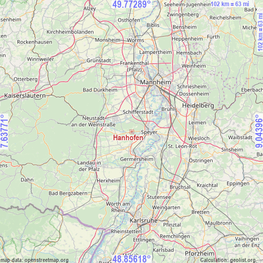
Hanhofen GPS coordinates[2]
49° 19' 0.012" North, 8° 20' 26.988" East
| Map corner | latitude | longitude |
|---|---|---|
| Upper-left | 49.77289°, | 7.63771° |
| Center: | 49.31667°, | 8.34083° |
| Lower-right: | 48.85618°, | 9.04396° |
| Map W x H: | 101.9×101.9 km | = 63.3×63.3mi |
| max Lat: | 55.01917° ⇑78.5% North |
| Hanhofen: | 49.31667° |
| min Lat: | ⇓21.5% South 47.40724° |
| min Long | Hanhofen | max Long |
| 5.92978° | 8.34083° | 14.98853° |
| W 27.5%⇐ | ⇒72.5% E |
Elevation
Elevation of Hanhofen is 107 m = 351 ft, and this is 142.1 m = 466 ft below average elevation for this country.
| Max E: |
1256 m = 4121 ft | 67.1% |
| Avg. | 249.1 m = 817 ft | |
| Hanhofen | 107 m = 351 ft | |
Min E: |
-5 m = -16 ft | 32.9% |
See also: Germany elevation on elevation.city.
Geographical zone
Hanhofen is located in North temperate zone (between Tropic of Cancer and the Arctic Circle). Distance of this North polar circle is 1917.7 km =1191.6 mi to North.| Distance of | km | miles | from Hanhofen |
|---|---|---|---|
| North Pole | 4523.6 | 2810.8 | to North |
| Arctic Circle | 1917.7 | 1191.6 | to North |
| Tropic Cancer | 2877.6 | 1788.1 | to South |
| Equator | 5483.5 | 3407.3 | to South |


Nearby cities:
15 places around Hanhofen: (largest is in red/bold)
• Altdorf
9.6 km =6 mi,  250°
250°
• Böbingen
8.4 km =5.2 mi,  244°
244°
• Böhl-Iggelheim
7.6 km =4.7 mi,  339°
339°
• Dudenhofen
3.5 km =2.2 mi,  86°
86°
• Freisbach
7.1 km =4.4 mi,  224°
224°
• Gommersheim
6.1 km =3.8 mi, 242°
• Harthausen
2.5 km =1.6 mi,  173°
173°
• Haßloch
7.9 km =4.9 mi,  310°
310°
• Lingenfeld
7 km =4.3 mi,  181°
181°
• Lustadt
9.3 km =5.8 mi,  211°
211°
• Schifferstadt
8 km =5 mi,  19°
19°
• Schwegenheim
5.3 km =3.3 mi,  189°
189°
• Speyer
6.6 km =4.1 mi, 85°
• Weingarten
7.5 km =4.7 mi, 211°
• Westheim
7.9 km =4.9 mi, 189°
Sources, notices
• [Note1] Compared only with cities in Germany existing in our database
• [Src1] Map data: © OpenStreetMap contributors (CC-BY-SA)
• [Src2] Other city data from geonames.org with taken over terms of usage.
• [Src3] Geographical zone / Annual Mean Temperature by Robert A. Rohde @ Wikipedia
