Pfronstetten geodata
Pfronstetten (Baden-Württemberg) is a seat of a fourth-order administrative division; located in Germany in Europe/Berlin (GMT+2) time zone. With population of 1,581 people, there are 5719 cities with bigger population in this country. Compared to other cities in Germany, 91.6% of cities are located further ↑North; 60% of cities are located further →East and 98.7% of cities have lower elevation than Pfronstetten. Note1
Administrative division(s):
- Level 1: Baden-Württemberg
- Level 2: Tübingen Region
- Level 3: Landkreis Reutlingen
- Level 4: Pfronstetten


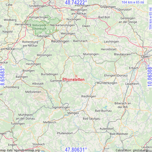
Pfronstetten GPS coordinates[2]
48° 16' 35.076" North, 9° 21' 35.82" East
| Map corner | latitude | longitude |
|---|---|---|
| Upper-left | 48.74222°, | 8.65683° |
| Center: | 48.27641°, | 9.35995° |
| Lower-right: | 47.80631°, | 10.06308° |
| Map W x H: | 104.1×104.1 km | = 64.7×64.7mi |
| max Lat: | 55.01917° ⇑91.6% North |
| Pfronstetten: | 48.27641° |
| min Lat: | ⇓8.4% South 47.40724° |
| min Long | Pfronstetten | max Long |
| 5.92978° | 9.35995° | 14.98853° |
| W 40%⇐ | ⇒60% E |
Elevation
Elevation of Pfronstetten is 754 m = 2474 ft, and this is 504.9 m = 1656 ft above average elevation for this country.
| Max E: |
1256 m = 4121 ft | 1.3% |
| Pfronstetten | 754 m 2474 ft | |
| Avg. | 249.1 m = 817 ft | |
Min E: |
-5 m = -16 ft | 98.7% |
See also: Germany elevation on elevation.city.
Geographical zone
Pfronstetten is located in North temperate zone (between Tropic of Cancer and the Arctic Circle). Distance of this North polar circle is 2033.3 km =1263.4 mi to North.| Distance of | km | miles | from Pfronstetten |
|---|---|---|---|
| North Pole | 4639.2 | 2882.7 | to North |
| Arctic Circle | 2033.3 | 1263.4 | to North |
| Tropic Cancer | 2761.9 | 1716.2 | to South |
| Equator | 5367.8 | 3335.4 | to South |


Nearby cities:
15 places around Pfronstetten: (largest is in red/bold)
• Altheim
16 km =9.9 mi,  156°
156°
• Emeringen
12.6 km =7.8 mi,  112°
112°
• Gammertingen
10.4 km =6.5 mi,  255°
255°
• Gomadingen
13.9 km =8.6 mi,  9°
9°
• Hayingen
8.7 km =5.4 mi,  90°
90°
• Hettingen
11.6 km =7.2 mi,  234°
234°
• Langenenslingen
14.3 km =8.9 mi,  174°
174°
• Lauterach
16.5 km =10.3 mi,  97°
97°
• Neufra
13.5 km =8.4 mi, 256°
• Obermarchtal
16.5 km =10.3 mi, 107°
• Rechtenstein
14.3 km =8.9 mi, 106°
• Riedlingen
16 km =9.9 mi,  147°
147°
• Trochtelfingen
9.2 km =5.7 mi,  292°
292°
• Veringenstadt
15 km =9.3 mi, 227°
• Zwiefalten
8.9 km =5.5 mi,  121°
121°
Sources, notices
• [Note1] Compared only with cities in Germany existing in our database
• [Src1] Map data: © OpenStreetMap contributors (CC-BY-SA)
• [Src2] Other city data from geonames.org with taken over terms of usage.
• [Src3] Geographical zone / Annual Mean Temperature by Robert A. Rohde @ Wikipedia
