Gnarrenburg geodata
Gnarrenburg (Lower Saxony) is a seat of a fourth-order administrative division; located in Germany in Europe/Berlin (GMT+2) time zone. With population of 9,504 people, there are 1704 cities with bigger population in this country. Compared to other cities in Germany, 84.4% of cities are located further ↓South; 65.5% of cities are located further →East and 94.3% of cities have higher elevation than Gnarrenburg. Note1


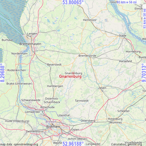
Gnarrenburg GPS coordinates[2]
53° 22' 59.988" North, 9° 0' 0" East
| Map corner | latitude | longitude |
|---|---|---|
| Upper-left | 53.80065°, | 8.29688° |
| Center: | 53.38333°, | 9° |
| Lower-right: | 52.96188°, | 9.70313° |
| Map W x H: | 93.3×93.3 km | = 58×58mi |
| max Lat: | 55.01917° ⇑15.6% North |
| Gnarrenburg: | 53.38333° |
| min Lat: | ⇓84.4% South 47.40724° |
| min Long | Gnarrenburg | max Long |
| 5.92978° | 9° | 14.98853° |
| W 34.5%⇐ | ⇒65.5% E |
Elevation
Elevation of Gnarrenburg is 10 m = 33 ft, and this is 239.1 m = 784 ft below average elevation for this country.
| Max E: |
1256 m = 4121 ft | 94.3% |
| Avg. | 249.1 m = 817 ft | |
| Gnarrenburg | 10 m = 33 ft | |
Min E: |
-5 m = -16 ft | 5.7% |
See also: Germany elevation on elevation.city.
Geographical zone
Gnarrenburg is located in North temperate zone (between Tropic of Cancer and the Arctic Circle). Distance of this North polar circle is 1465.5 km =910.6 mi to North.| Distance of | km | miles | from Gnarrenburg |
|---|---|---|---|
| North Pole | 4071.4 | 2529.8 | to North |
| Arctic Circle | 1465.5 | 910.6 | to North |
| Tropic Cancer | 3329.8 | 2069 | to South |
| Equator | 5935.7 | 3688.3 | to South |


Nearby cities:
15 places around Gnarrenburg: (largest is in red/bold)
• Barchel
9.5 km =5.9 mi,  13°
13°
• Basdahl
6.9 km =4.3 mi,  0°
0°
• Beverstedt
13.3 km =8.3 mi,  295°
295°
• Breddorf
11.4 km =7.1 mi,  151°
151°
• Frelsdorf
13.7 km =8.5 mi,  330°
330°
• Hambergen
14.3 km =8.9 mi,  234°
234°
• Hipstedt
11.3 km =7 mi,  348°
348°
• Kirchwistedt
8.5 km =5.3 mi, 301°
• Lübberstedt
14.4 km =8.9 mi,  247°
247°
• Oerel
11.6 km =7.2 mi,  16°
16°
• Ostereistedt
14.4 km =8.9 mi,  129°
129°
• Rhade
9.7 km =6 mi, 128°
• Sandbostel
9 km =5.6 mi,  71°
71°
• Selsingen
14.2 km =8.8 mi,  94°
94°
• Vollersode
7.8 km =4.8 mi,  224°
224°
Sources, notices
• [Note1] Compared only with cities in Germany existing in our database
• [Src1] Map data: © OpenStreetMap contributors (CC-BY-SA)
• [Src2] Other city data from geonames.org with taken over terms of usage.
• [Src3] Geographical zone / Annual Mean Temperature by Robert A. Rohde @ Wikipedia
