Selsingen geodata
Selsingen (Lower Saxony) is a seat of a fourth-order administrative division; located in Germany in Europe/Berlin (GMT+2) time zone. With population of 3,310 people, there are 3747 cities with bigger population in this country. Compared to other cities in Germany, 84.3% of cities are located further ↓South; 62.1% of cities are located further →East and 88.3% of cities have higher elevation than Selsingen. Note1


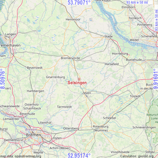
Selsingen GPS coordinates[2]
53° 22' 23.844" North, 9° 12' 46.404" East
| Map corner | latitude | longitude |
|---|---|---|
| Upper-left | 53.79071°, | 8.50976° |
| Center: | 53.37329°, | 9.21289° |
| Lower-right: | 52.95174°, | 9.91601° |
| Map W x H: | 93.3×93.3 km | = 58×58mi |
| max Lat: | 55.01917° ⇑15.7% North |
| Selsingen: | 53.37329° |
| min Lat: | ⇓84.3% South 47.40724° |
| min Long | Selsingen | max Long |
| 5.92978° | 9.21289° | 14.98853° |
| W 37.9%⇐ | ⇒62.1% E |
Elevation
Elevation of Selsingen is 26 m = 85 ft, and this is 223.1 m = 732 ft below average elevation for this country.
| Max E: |
1256 m = 4121 ft | 88.3% |
| Avg. | 249.1 m = 817 ft | |
| Selsingen | 26 m = 85 ft | |
Min E: |
-5 m = -16 ft | 11.7% |
See also: Germany elevation on elevation.city.
Geographical zone
Selsingen is located in North temperate zone (between Tropic of Cancer and the Arctic Circle). Distance of this North polar circle is 1466.6 km =911.3 mi to North.| Distance of | km | miles | from Selsingen |
|---|---|---|---|
| North Pole | 4072.5 | 2530.5 | to North |
| Arctic Circle | 1466.6 | 911.3 | to North |
| Tropic Cancer | 3328.6 | 2068.3 | to South |
| Equator | 5934.6 | 3687.6 | to South |


Nearby cities:
15 places around Selsingen: (largest is in red/bold)
• Anderlingen
6 km =3.7 mi,  88°
88°
• Breddorf
12.5 km =7.8 mi,  224°
224°
• Bremervörde
13.2 km =8.2 mi,  339°
339°
• Brest
14.2 km =8.8 mi,  52°
52°
• Deinstedt
5 km =3.1 mi,  15°
15°
• Farven
9.6 km =6 mi, 45°
• Gnarrenburg
14.2 km =8.8 mi,  274°
274°
• Heeslingen
10.2 km =6.3 mi,  128°
128°
• Kirchtimke
14.3 km =8.9 mi,  196°
196°
• Kutenholz
14 km =8.7 mi,  30°
30°
• Ostereistedt
8.7 km =5.4 mi, 200°
• Rhade
8.3 km =5.2 mi,  233°
233°
• Sandbostel
6.8 km =4.2 mi,  305°
305°
• Seedorf
2.9 km =1.8 mi,  152°
152°
• Zeven
9.5 km =5.9 mi, 153°
Sources, notices
• [Note1] Compared only with cities in Germany existing in our database
• [Src1] Map data: © OpenStreetMap contributors (CC-BY-SA)
• [Src2] Other city data from geonames.org with taken over terms of usage.
• [Src3] Geographical zone / Annual Mean Temperature by Robert A. Rohde @ Wikipedia
