Sandbostel geodata
Sandbostel (Lower Saxony) is a seat of a fourth-order administrative division; located in Germany in Europe/Berlin (GMT+2) time zone. With population of 842 people, there are 7733 cities with bigger population in this country. Compared to other cities in Germany, 84.6% of cities are located further ↓South; 63.5% of cities are located further →East and 94.8% of cities have higher elevation than Sandbostel. Note1


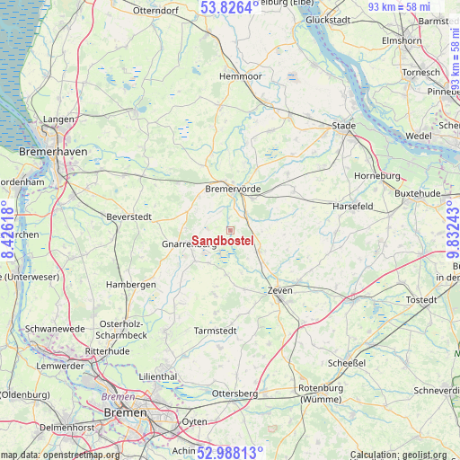
Sandbostel GPS coordinates[2]
53° 24' 33.588" North, 9° 7' 45.48" East
| Map corner | latitude | longitude |
|---|---|---|
| Upper-left | 53.8264°, | 8.42618° |
| Center: | 53.40933°, | 9.1293° |
| Lower-right: | 52.98813°, | 9.83243° |
| Map W x H: | 93.2×93.2 km | = 57.9×57.9mi |
| max Lat: | 55.01917° ⇑15.4% North |
| Sandbostel: | 53.40933° |
| min Lat: | ⇓84.6% South 47.40724° |
| min Long | Sandbostel | max Long |
| 5.92978° | 9.1293° | 14.98853° |
| W 36.5%⇐ | ⇒63.5% E |
Elevation
Elevation of Sandbostel is 9 m = 30 ft, and this is 240.1 m = 788 ft below average elevation for this country.
| Max E: |
1256 m = 4121 ft | 94.8% |
| Avg. | 249.1 m = 817 ft | |
| Sandbostel | 9 m = 30 ft | |
Min E: |
-5 m = -16 ft | 5.2% |
See also: Germany elevation on elevation.city.
Geographical zone
Sandbostel is located in North temperate zone (between Tropic of Cancer and the Arctic Circle). Distance of this North polar circle is 1462.6 km =908.8 mi to North.| Distance of | km | miles | from Sandbostel |
|---|---|---|---|
| North Pole | 4068.5 | 2528 | to North |
| Arctic Circle | 1462.6 | 908.8 | to North |
| Tropic Cancer | 3332.6 | 2070.8 | to South |
| Equator | 5938.6 | 3690.1 | to South |


Nearby cities:
15 places around Sandbostel: (largest is in red/bold)
• Anderlingen
12.2 km =7.6 mi,  108°
108°
• Barchel
9 km =5.6 mi,  315°
315°
• Basdahl
9.4 km =5.8 mi,  294°
294°
• Bei der Höhne
11.6 km =7.2 mi,  354°
354°
• Breddorf
13.4 km =8.3 mi,  193°
193°
• Bremervörde
8.4 km =5.2 mi,  6°
6°
• Deinstedt
6.9 km =4.3 mi,  83°
83°
• Farven
12.7 km =7.9 mi, 77°
• Gnarrenburg
9 km =5.6 mi,  251°
251°
• Hipstedt
13.6 km =8.5 mi,  307°
307°
• Oerel
9.8 km =6.1 mi,  327°
327°
• Ostereistedt
12.4 km =7.7 mi,  168°
168°
• Rhade
9 km =5.6 mi, 186°
• Seedorf
9.5 km =5.9 mi,  133°
133°
• Selsingen
6.8 km =4.2 mi, 125°
Sources, notices
• [Note1] Compared only with cities in Germany existing in our database
• [Src1] Map data: © OpenStreetMap contributors (CC-BY-SA)
• [Src2] Other city data from geonames.org with taken over terms of usage.
• [Src3] Geographical zone / Annual Mean Temperature by Robert A. Rohde @ Wikipedia
