Glückstadt geodata
Glückstadt (Schleswig-Holstein) is a populated place; located in Germany in Europe/Berlin (GMT+2) time zone. With population of 12,121 people, there are 1352 cities with bigger population in this country. Compared to other cities in Germany, 89.9% of cities are located further ↓South; 58.9% of cities are located further →East and 98.1% of cities have higher elevation than Glückstadt. Note1
Administrative division(s):
- Level 1: Schleswig-Holstein
- Level 3: Kreis Steinburg
- Level 4: Glückstadt


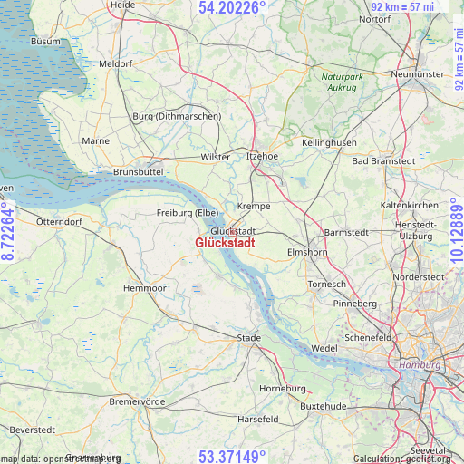
Glückstadt GPS coordinates[2]
53° 47' 20.148" North, 9° 25' 32.736" East
| Map corner | latitude | longitude |
|---|---|---|
| Upper-left | 54.20226°, | 8.72264° |
| Center: | 53.78893°, | 9.42576° |
| Lower-right: | 53.37149°, | 10.12889° |
| Map W x H: | 92.4×92.4 km | = 57.4×57.4mi |
| max Lat: | 55.01917° ⇑10.1% North |
| Glückstadt: | 53.78893° |
| min Lat: | ⇓89.9% South 47.40724° |
| min Long | Glückstadt | max Long |
| 5.92978° | 9.42576° | 14.98853° |
| W 41.1%⇐ | ⇒58.9% E |
Elevation
Elevation of Glückstadt is 2 m = 7 ft, and this is 247.1 m = 811 ft below average elevation for this country.
| Max E: |
1256 m = 4121 ft | 98.1% |
| Avg. | 249.1 m = 817 ft | |
| Glückstadt | 2 m = 7 ft | |
Min E: |
-5 m = -16 ft | 1.9% |
See also: Germany elevation on elevation.city.
Geographical zone
Glückstadt is located in North temperate zone (between Tropic of Cancer and the Arctic Circle). Distance of this North polar circle is 1420.4 km =882.6 mi to North.| Distance of | km | miles | from Glückstadt |
|---|---|---|---|
| North Pole | 4026.3 | 2501.8 | to North |
| Arctic Circle | 1420.4 | 882.6 | to North |
| Tropic Cancer | 3374.8 | 2097 | to South |
| Equator | 5980.8 | 3716.3 | to South |


Nearby cities:
15 places around Glückstadt: (largest is in red/bold)
• Altenmoor
9.6 km =6 mi,  104°
104°
• Bahrenfleth
9.2 km =5.7 mi,  5°
5°
• Blomesche Wildnis
1.4 km =0.9 mi,  334°
334°
• Borsfleth
5 km =3.1 mi, 5°
• Drochtersen
9.2 km =5.7 mi,  197°
197°
• Elskop
4.9 km =3 mi,  50°
50°
• Grevenkop
9.3 km =5.8 mi, 49°
• Herzhorn
3.8 km =2.4 mi, 99°
• Kollmar
7.5 km =4.7 mi,  152°
152°
• Krempdorf
5.6 km =3.5 mi,  28°
28°
• Krempe
6.7 km =4.2 mi,  37°
37°
• Sommerland
7.5 km =4.7 mi,  77°
77°
• Süderau
6.7 km =4.2 mi,  62°
62°
• Wewelsfleth
7 km =4.3 mi,  346°
346°
• Wischhafen
7.2 km =4.5 mi,  265°
265°
Sources, notices
• [Note1] Compared only with cities in Germany existing in our database
• [Src1] Map data: © OpenStreetMap contributors (CC-BY-SA)
• [Src2] Other city data from geonames.org with taken over terms of usage.
• [Src3] Geographical zone / Annual Mean Temperature by Robert A. Rohde @ Wikipedia
