Bahrenfleth geodata
Bahrenfleth (Schleswig-Holstein) is a seat of a fourth-order administrative division; located in Germany in Europe/Berlin (GMT+2) time zone. With population of 602 people, there are 8809 cities with bigger population in this country. Compared to other cities in Germany, 90.9% of cities are located further ↓South; 58.7% of cities are located further →East and 99.1% of cities have higher elevation than Bahrenfleth. Note1
Administrative division(s):
- Level 1: Schleswig-Holstein
- Level 3: Kreis Steinburg
- Level 4: Bahrenfleth


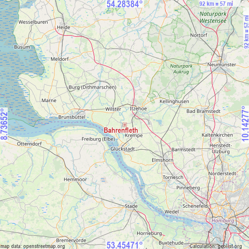
Bahrenfleth GPS coordinates[2]
53° 52' 16.788" North, 9° 26' 22.704" East
| Map corner | latitude | longitude |
|---|---|---|
| Upper-left | 54.28384°, | 8.73652° |
| Center: | 53.87133°, | 9.43964° |
| Lower-right: | 53.45471°, | 10.14277° |
| Map W x H: | 92.2×92.2 km | = 57.3×57.3mi |
| max Lat: | 55.01917° ⇑9.1% North |
| Bahrenfleth: | 53.87133° |
| min Lat: | ⇓90.9% South 47.40724° |
| min Long | Bahrenfleth | max Long |
| 5.92978° | 9.43964° | 14.98853° |
| W 41.3%⇐ | ⇒58.7% E |
Elevation
Elevation of Bahrenfleth is 0 m = 0 ft, and this is 249.1 m = 817 ft below average elevation for this country.
| Max E: |
1256 m = 4121 ft | 99.1% |
| Avg. | 249.1 m = 817 ft | |
| Bahrenfleth | 0 m = 0 ft | |
Min E: |
-5 m = -16 ft | 0.9% |
See also: Germany elevation on elevation.city.
Geographical zone
Bahrenfleth is located in North temperate zone (between Tropic of Cancer and the Arctic Circle). Distance of this North polar circle is 1411.2 km =876.9 mi to North.| Distance of | km | miles | from Bahrenfleth |
|---|---|---|---|
| North Pole | 4017.1 | 2496.1 | to North |
| Arctic Circle | 1411.2 | 876.9 | to North |
| Tropic Cancer | 3384 | 2102.7 | to South |
| Equator | 5989.9 | 3722 | to South |


Nearby cities:
15 places around Bahrenfleth: (largest is in red/bold)
• Beidenfleth
2 km =1.2 mi,  297°
297°
• Bekmünde
6 km =3.7 mi,  4°
4°
• Borsfleth
4.2 km =2.6 mi,  185°
185°
• Dammfleth
6 km =3.7 mi,  313°
313°
• Dägeling
6.3 km =3.9 mi,  77°
77°
• Elskop
6.7 km =4.2 mi,  154°
154°
• Heiligenstedtenerkamp
3.7 km =2.3 mi,  30°
30°
• Hodorf
3.3 km =2.1 mi,  348°
348°
• Krempdorf
4.6 km =2.9 mi,  157°
157°
• Krempe
5 km =3.1 mi,  140°
140°
• Kremperheide
3.1 km =1.9 mi,  54°
54°
• Krempermoor
2.8 km =1.7 mi, 76°
• Neuenbrook
6.2 km =3.9 mi,  101°
101°
• Stördorf
5 km =3.1 mi, 349°
• Wewelsfleth
3.5 km =2.2 mi,  227°
227°
Sources, notices
• [Note1] Compared only with cities in Germany existing in our database
• [Src1] Map data: © OpenStreetMap contributors (CC-BY-SA)
• [Src2] Other city data from geonames.org with taken over terms of usage.
• [Src3] Geographical zone / Annual Mean Temperature by Robert A. Rohde @ Wikipedia
